
The 2002 Biscuit Fire Suppression Actions and Impacts
by Timothy Ingalsbee, Ph.D.
Western Fire Ecology Center
American Lands Alliance
May 2004
EXECUTIVE SUMMARY
The newsmedia and politicians commonly portray firefighting incidents in the most superficial and sensationalistic terms, as essentially heroic military-style campaigns against the destructive forces of Nature. Federal closures of National Forests are routinely declared during wildfires, thereby prohibiting on-the-ground monitoring of firefighting actions by the public and the press. The result is that fire suppression operations are rarely critically examined, and the public is kept in the dark about firefighting actions and their associated risks, costs, and impacts.
Collateral Damage: The Environmental Effects of Firefighting describes the direct, indirect, and cumulative environmental impacts of firefighting, and offers specific examples from the 2002 Biscuit Fire in southern Oregon. The 499,570 acre Biscuit Fire was the Nation’s largest wildfire in 2002, and at a cost of over $155 million, became the world’s most expensive firefighting incident in history. The Biscuit Fire area is currently the site of the largest Forest Service timber sale proposal in modern history as the agency intends to “salvage” log over half a billion board feet of burned trees, including trees that were felled for firelines or were killed during suppression firing operations. The Biscuit Fire suppression actions and post-fire logging proposal has generated intense public controversy that continues to grow.
The Cumulative Ecological Effects of Fire Exclusion
The past century’s policy to systematically suppress and exclude all wildland fires has led to widespread alteration and degradation of many fire-adapted ecosystems. Ironically, one of the cumulative effects of past fire suppression and fire exclusion is that each time a wildfire is successfully contained and controlled, this makes it more difficult to suppress future wildfires, increasing the probability that they will defy fire control efforts.
In the Siskiyou National Forest an average 20,833 acres burned annually until the 1940s, but increasing investments in suppression resources over the next 60 years reduced the average annual burned acreage to only 2,772 acres, just 13 percent of the pre-suppression era average amount. In some areas—but not all–this caused significant changes in the density, structure and composition of live vegetation, and the size, amounts and distribution of dead fuels. Moreover, fire exclusion has caused a decline in landscape and biological diversity: pine and oak savanna, deciduous woodland, and meadow habitats that were historically maintained by relatively frequent low-intensity fires have become smaller by up to 50 percent in the Siskiyou National Forest.
The ecological changes in vegetation and fuels caused by past fire exclusion were important factors influencing fire spread and intensity, but like other large wildfire events, the Biscuit Fire was primarily influenced by climate and weather factors. At the time the Biscuit Fire started, the area had been through prolonged severe drought and was experiencing record-breaking temperatures. During the terrain and wind-driven “blow-up” episodes, the wildfire burned rapidly and intensely across many different vegetation types and fuel profiles including sparsely-vegetated “serpentine” soil areas and deforested clearcuts. Moreover, suppression firing operations played an important role in the spread of the fire.
The Direct Environmental Effects of Fire Suppression
Fireline Construction
Constructing firelines by handcrews or heavy equipment results in a number of direct environmental impacts: it kills and removes vegetation; displaces, compacts, and erodes soil; and degrades water quality. When dozerlines are cut into roadless areas they also create long-term visual scars that can ruin the wilderness experience of roadless area recreationists. Site-specific impacts of firelines may be highly significant, especially for interior-dwelling wildlife species sensitive to fragmentation and edge effects.
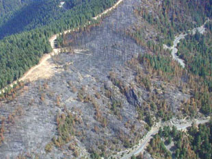
On the Biscuit Fire approximately 405 miles of fireline were constructed; this compares to 500 miles of existing logging roads in the fire area. Firelines were constructed through highly erosive slopes comprised of serpentine soils that are prone to gully erosion and are slow to revegetate. Over 57 linear miles of dozerline were carved into serpentine soils; in some places dozerlines were up to 40 feet wide.
Out of approximately 160 miles of dozerlines, at least nine miles were constructed within riparian zones and involved 196 stream crossings. These activities dumped sediment directly into streams, degrading water quality and fish habitat.
Tree Felling
Another component of fire suppression involves tree cutting and vegetation removal. Both small-diameter understory and large-diameter overstory trees are felled to construct firelines, helispots, and safety zones.
Firelines constructed in the northern portions of the Biscuit Fire were located in areas of mature/old-growth forest, and many large- diameter trees were felled by bulldozers and fellerbunchers. Many of these trees were subsequently cut to commercial length, decked, and later sold in so-called “hazard tree” and “salvage” timber sales.
Besides habitat loss and scenic degradation, an additional impact of tree felling along firelines is, ironically, the creation of new fuel hazards by leaving “windthrows” of downed woody debris and vegetation. Many Biscuit firelines now pose a significant fire hazard requiring expensive fuels reduction treatments.
Chemical Use
A host of different toxic chemical fire retardants are used during fire suppression operations. Concentrated doses of retardant in aquatic habitats can immediately kill fish, or lead to algae blooms that kill fish over time. Some retardants degrade into cyanide at levels deadly to amphibians. When dumped on the ground, the fertilizer in retardant can stimulate the growth of invasive weeds that can enter remote sites from seeds transported inadvertently by suppression crews and their equipment.
Suppression policies call for pilots to avoid dumping retardant into water bodies, but airtankers were ordered to the Biscuit Fire even when visibility was poor due to smoke conditions, and communication was not available to direct them to targets. Consequently, fire retardant was dropped within some riparian areas, including heavy direct applications into tributaries of the lower Illinois River. In just one zone of the Biscuit Fire, 491,547 gallons of the fire retardant, Phos-Chek, was used at a cost of $594,776, with over 104,664 gallons used on a single day (August 14).
Water Use
The water-borne pathogen, Phytophthora lateralis is present throughout the Siskiyou, and is usually fatal to Port Orford cedars (“POC”). Chlorine was used to treat potentially contaminated water that was used in fire engines, tank trucks, and helicopter buckets, and to wash vehicles before entering uninfected POC areas. A total of about 4.5 million gallons of chlorinated water had been used in suppression actions by August, 2002. Yet, 227,960 gallons of untreated contaminated water was dumped on the boundary of a POC protection area located near Gasquet, California. Untreated water was also permitted to be dropped from helicopters on ridgetops under the assumption that POC grows only in lower drainages. New infestations of POC disease are expected to result from suppression equipment using contaminated water.
Other impacts to fish and riparian habitats in the Biscuit Fire occurred due to water pumping, the use of chlorine bleach to disinfect water, and improper pumping procedures. When a water tender broke down and the operator jettisoned his entire load of chlorinated water into the stream, this killed approximately 80 native cutthroat fish.
Suppression Firing Operations
One of the many paradoxes of fire suppression is that it involves a considerable amount of human-caused fire reintroduction under the philosophy of “fighting fire with fire.” The most routine form of suppression firing, “burnout,” occurs along nearly every linear foot of perimeter fireline. Another form of suppression firing, “backfiring,” occurs when firefighters ignite a high-intensity fire near a wildfire’s flaming edge, with or without a secured containment line. In the “kill zone” between a burnout/backfire and the wildfire edge, radiant heat intensity can reach peak levels, causing extreme severity effects and high mortality of wildlife by entrapping them between two high-intensity flame fronts.
Burning out is commonly used on wildfire “complexes” (a cluster of smaller wildfires) in order to merge them together into a single large fire perimeter. As well, large unburned “green islands” located far inside firelines are often deliberately ignited. During indirect attack strategies, burnout operations can take place several miles away from the edge of a wildfire, or alternately, several miles away from firelines. Consequently, firing operations can greatly add to the total acreage of wildfires, and cause a range of low to extreme fire behavior and severity.
An historically unprecedented amount of burnout occurred on the Biscuit Fire. Approximately 106,690 acres were burned out in just one (out of four total) incident management zones—the equivalent of 167 square miles. Some burnouts lasted several days, extending over 30 miles and encompassing 30,000 acres in a single firing operation. In fact, some of the Biscuit burnouts were larger than most of the wildfires burning elsewhere in Oregon in 2002. On several occasions during the Biscuit Fire, burnouts were the major source of active burning or fire spread.
Despite agency and newsmedia claims that the firing operations saved homes and communities located in the Illinois Valley, during the episodes of major fire spread the winds were mainly pushing the wildfire away from these communities. Ironically, the closest the Biscuit Fire ever came to the communities in the Illinois Valley were largely the result of the burnout operations, not the wildfire itself. Backfires ignited near the communities of Oak Flat actually destroyed some homes and property.
The Indirect Environmental Effects of Fire Suppression
Off-Highway Vehicle Use
Firelines, especially dozerlines, can become new “ghost” roads that enable unauthorized or illegal OHV users to drive into roadless areas. These OHVs create further soil and noise disturbance, can spread garbage and invasive weeds, and increase the risk of accidental human-caused fires. Motorcycles are reportedly already using some of the Biscuit dozerlines, causing extensive soil rutting in several areas.
Road Reconstruction
Roads that have been blockaded, decommissioned, or obliterated in order to protect wildlife or other natural resource values are often reopened for firefighter vehicle access or use as firelines. The Biscuit Fire suppression effort reopened and reconstructed many abandoned or barricaded roads, and extended the length of some roads. Dozers also improved old jeep trails (“4WD” roads) for use as firelines or firefighter vehicle access, including a jeep trail that was widened up to 40 feet wide for a length of three and a half miles. These reopened roads and improved jeep trails now invite unauthorized OHV use.
Spread of Noxious and Invasive Weeds
Both vegetation removal and soil disturbance by wildfire and suppression activities can create ideal conditions for the spread of invasive weeds, which can significantly alter the native species composition of ecosystems, and in some cases can change the natural fire regime to a more fire-prone condition. Firefighters and their vehicles can be vectors for transporting invasive weed seeds deep into previously uninfested wildlands. On the Biscuit Fire, firefighters were repeatedly staged and camped in areas that had known populations of noxious weeds, and the potential for spread of these weeds is very high.
Post-Fire Logging
Both so-called “salvage” logging and “hazard tree” removal often follows wildfire suppression incidents. Approximately 11,275 acres of proposed salvage logging units in the Forest Service’s preferred alternative for the Biscuit Fire Recovery Project are located inside areas in Zone One that were deliberately burned out. The Forest Service also allowed commercial logging of approximately five million board feet of “hazard trees” alongside roads that were used for firelines, The Siskiyou National Forest is now proposing to commercially extract 14 million board feet of trees in order to create 309 miles of fuelbreaks for future firelines.
Suppression Impacts on Special Emphasis Management Areas
Botanical Areas
The Klamath-Siskiyou is internationally recognized as one of the most botanically significant ecoregions on the North American continent, and has been proposed as a world heritage site and biosphere reserve by scientists from UNESCO. Botanical Areas (BAs) have been established to protect rare, sensitive, threatened and endangered endemic plants and to preserve the region’s native biodiversity. Fire suppression and/or BAER activities adversely affected 10 of these BAs on the Siskiyou National Forest.
Research Natural Areas
Research Natural Areas (RNAs) are established for non-manipulative research, observation, and study of naturally occurring physical and biological processes without destructive human intervention. Biscuit Fire suppression actions affected the Hoover Gulch and Lemmingsworth Gulch RNAs.
Heritage Sites
At least 168 heritage sites had been documented within the Biscuit Fire perimeter prior to the fire, and an additional 25,000 acres have not yet been surveyed but are considered to have high probability for new sites. Degradation due to fire suppression impacts, mainly ground-disturbing activities for construction of firelines and safety zones, may have compromised their eligibility for the National Register of Historic Places.
Late-Successional and Riparian Reserves
Late-Successional Reserves (LSRs) and Riparian Reserves (RRs) were established by the Northwest Forest Plan to protect rare and sensitive old-growth and aquatic habitats for endangered species such as the northern spotted owl and salmon. Ironically, aggressive fire suppression operations are allowed inside LSRs and RRs; thus, chainsaws, bulldozers, helicopters and airtankers, chemical retardants, and ignition devices may all be deployed inside these sensitive areas. Several tens of thousands of acres of LSRs and RRs on the eastern half of the Biscuit Fire were scorched by suppression firing operations conducted between August 8-20.
Wilderness Areas
As much as 99% of the 179,870 acre Kalmiopsis Wilderness Area was burned during the Biscuit Fire. For the most part, though, suppression activities stayed out of the Wilderness Area, but the southern section of the perimeter fireline was plotted through the Kalmiopsis Wilderness.
Roadless Areas
In general, roadless areas are least altered by past management activities including fire suppression, have the highest ecological integrity, and the highest resilience to wildland fire compared to logged and roaded landscapes. On the Biscuit Fire, indirect attack strategies focused most of the suppression activities on the network of logging roads in the Siskiyou National Forest, but the southeastern perimeter containment line was routed right through an unroaded section of the South Kalmiopsis Roadless Area. Most suppression activity in the North Kalmiopsis Roadless Area was burnout.
Wild and Scenic Rivers
The goal of Wild and Scenic River (WSR) management is to maintain the river environment in a natural state while also providing for recreational opportunities. During the Biscuit, Fire suppression operations adversely affected portion of the Chetco, Illinois, and North Fork of the Smith WSRs.
Meadow Communities
Natural meadows are attractive sites for locating firelines, helispots, safety zones, and fire camps, but these suppression activities can cause significant, long-term damage to meadow habitats. During the Biscuit Fire, firefighting operations–particularly construction of safety zones–damaged several meadows. Trees were felled, dozers removed sod, and vehicle access was improved, leaving the meadows denuded down to mineral soil in places, covered with downed logs and slash, and scarred by dozer berms. These impacts necessitated expensive post-fire rehabilitation efforts.
Conclusion
Land management agencies may never get off the “treadmill” of increasing fuel accumulations, declining biodiversity and forest health, and large severe wildfires unless and until aggressive fire suppression actions are reduced in number and scale. Proactive programs for fire management planning, public fire ecology education, community fire preparation, hazardous fuels reduction, and ecological forest restoration must be developed and implemented. Ultimately the only viable long-term solution to the current wildfire crisis is to reintroduce fire in fire-adapted ecosystems through prescribed burning and wildland fire use.
Recommendations
The ultimate goal is to make the need for aggressive fire suppression operations become the exception rather than the rule. Recommendations include:
- collaborative land and fire management planning that implements the Federal Wildland Fire Policy and complies with the National Environmental Policy Act (NEPA)
- a fire ecology education campaign for the general public and agency employees that informs people about the benefits of fire and the effects of suppression
- prioritization of the National Fire Plan on community fire preparation rather than fire exclusion/suppression in remote backcountry wildlands
- ecological fuels reduction and forest restoration projects that support fire reintroduction goals
- firefighter training, performance measures, and new research and development in minimum impact suppression tactics
- and end to the “blank check” deficit spending system for funding fire suppression by applying greater Congressional oversight and Administrative accountability for establishing fixed suppression budgets and limiting expenditures
- a programmatic NEPA analysis that compares the risks to firefighters, costs to taxpayers, and impacts to ecosystems from fire exclusion/suppression versus prescribed fire reintroduction and wildland fire use
All of the above policy recommendations can all help prevent the need for reactive emergency suppression actions.
Collateral Damage: The Environmental Effects of Firefighting makes the case for a programmatic NEPA analysis and informed public debate on the environmental effects of fire suppression. This analysis will help establish rationale for conducting safe, cost-efficient, and ecologically-sound prescribed burning and wildland fire use, instead of relying upon risky, fiscally wasteful, and ecologically destructive reactive wildfire suppression and post-fire salvage logging as the dominant fire and fuels management activities of the U.S. Forest Service.
INTRODUCTION
In 2002, severe drought coupled with record-breaking heat, steep mountainous terrain, high hazardous fuel accumulations, and numerous ignitions sparked by lightning storms and arsonists combined in several locations across the western U.S. to create “a perfect storm” of conditions required for large-scale, high-intensity wildfires. Indeed, the 2002 fire season featured over a dozen large wildfires including some of the largest incidents in over a century in the states of Colorado, Arizona, and Oregon.[1] In southern Oregon, fire danger indices in early July were uncharacteristically high, warning of a high potential for a large wildland fire with a low probability of success for firecrews to safely and effectively attack a wildfire.[2] On July 13th, a series of lightning strikes ignited five small fires in the Siskiyou National Forest: the Florence, Sourdough, Carter, Biscuit #1 and Biscuit #2 fires. Only the Carter Fire was successfully contained at initial attack. The Sourdough and both Biscuit Fires quickly burned together, and were renamed the Sour Biscuit Fire. Eventually, through a combination of natural fire spread and firefighter burning operations, the Florence and Sour Biscuit Fires were consolidated into a single wildfire incident on August 7th originally called the Florence Fire but later renamed the Biscuit Fire.
Despite the efforts of thousands of firefighters and hundreds of vehicles, aircraft, and equipment, the Biscuit Fire burned for nearly two months. The 499,570 acre Biscuit Fire became the Nation’s largest wildfire in 2002, and was the largest wildfire in Oregon for over a century. At a cost of over $155 million, the siege-like suppression operation also earned the distinction of being the world’s most expensive wildland fire suppression incident in history. Although the fire burned in a mosaic pattern within the natural range of variability for the Klamath-Siskiyou bioregion, the federal government, press, and politicians reacted to the wildfire as if it were a catastrophe. The Biscuit Fire area is currently the site of the largest Forest Service timber sale proposal in modern history as the agency intends to “salvage” log trees that burned during the wildfire.
The Biscuit Fire suppression effort generated public controversy that continues to grow. Congressmen McInnis (R-CO), Walden (R-OR) and DeFazio (D-OR) have requested an investigation by the General Accounting Office (GAO) into the suppression efforts on the Biscuit Fire. The scope of the GAO study is mostly focused on the reasons why the Forest Service did not take more aggressive actions immediately after the wildfire was first detected, but there is an urgent need for a critical examination of the entire breadth of Biscuit fire suppression actions and their environmental impacts. The newsmedia and politicians commonly portray firefighting incidents in the most superficial and sensationalistic terms, as essentially heroic military-style campaigns against the destructive forces of Nature. Consequently, not only are firefighting incidents rarely critically examined, but the public is often kept in the dark about firefighting actions and their associated social, economic, and ecological effects. Indeed, the Forest Service routinely declares federal closures during wildfires, and this effectively prevents on-the-ground monitoring of firefighting actions by the public and the press. In fact, the entire Siskiyou National Forest had a federal closure for much of the duration of the Biscuit Fire, extending to areas far away from the fire area.

Collateral Damage: The Environmental Effects of Firefighting presents brief descriptions of standard firefighting methods along with a general discussion of their cumulative, direct, and indirect environmental impacts. This general discussion is illustrated by site-specific examples from the Biscuit Fire, using data collected from suppression documents, post-fire assessments, and other official documents created by the U.S. Forest Service. Additionally, this report provides analysis of the relationship between areas ignited during suppression “burnout” operations and subsequent proposed post-fire salvage logging units. This report makes no judgments about the decisions of fire managers nor criticizes the efforts of wildland firefighters. It is assumed that the suppression strategies and tactics were planned and implemented with the highest concerns for the safety of firefighters and the public, protection of private property, local communities, and natural resources. However, from the evidence and analysis presented this report makes the case for a new comprehensive, proactive wildland fire management policy that prioritizes completion of collaborative fire management plans, educates the public about essential fire ecology processes, prepares rural communities for prescribed and wildland fires, implements hazardous fuels reduction and ecological forest restoration projects, utilizes minimum impact suppression tactics, and makes every fire management action serve pre-planned ecological objectives. These new policies, programs and practices are necessary for conducting cost-efficient and ecologically-sound wildland fire use management and prescribed burning, instead of relying upon fiscally wasteful and ecologically destructive reactive wildfire suppression and salvage logging as the dominant fire and fuels management activities of the U.S. Forest Service.
THE CUMULATIVE ECOLOGICAL EFFECTS OF FIRE EXCLUSION
The primary objective of most fire suppression incidents is to “contain and control” wildfire by constructing a fireline around the perimeter of a wildfire, and thereby attempt to prevent it from further spreading across the landscape. Absolute fire exclusion is impossible given the abundance of natural lightning and accidental human ignitions, but the policy of systematic suppression to contain nearly all fires and limit their size and duration has been a relatively effective method of excluding fires from areas that otherwise would and should have burned. Excessive accumulations of surface fuels and understory vegetation can result from fire exclusion, and this tends to increase fire intensity when these areas eventually, inevitably burn. Thus, the irony of fire exclusion through fire suppression is that each time a wildfire is “successfully” contained and controlled, this cumulatively causes adverse ecological effects that make it more difficult to suppress future wildfires, increasing the probability that they will defy fire control efforts.
In the Siskiyou National Forest, for example, fires burned an average 20,833 acres annually until the 1940s, and even though the Forest Service actively engaged in fire suppression, it was relatively ineffective in the rugged, mountainous terrain. Throughout much of the Biscuit fire area, the landscape had a fairly frequent fire regime (15-60 year fire return intervals) and most fires were of low-to-moderate severity. Then in 1940 the Siskiyou National Forest established one of the Nation’s first smokejumper bases, located in Cave Junction in Southern Oregon. Increasing investments in suppression resources over the next six decades reduced the average annual burned acreage to only 2,772 acres, just 13 percent of the pre-suppression era average amount.[3] The Forest Service estimates that approximately 203,806 acres of the Biscuit Fire is characterized by Fire Regime I (high frequency/low severity regime), but from two to four fire cycles may have been missed due to fire exclusion policies and effective fire suppression actions since the 1940s. In some areas—but not all–this caused significant changes in the density, structure and composition of live vegetation, and the size, amounts and distribution of dead fuels.[4]
The ecological changes in vegetation and fuels caused by fire exclusion were important factors, but were not the primary reason that the Biscuit Fire burned with such great size and intensity. In general, large fire events are driven by climate and weather conditions, and this was especially true for the Biscuit Fire where two consecutive drought years coupled with high temperatures, low humidity, and high winds caused the major fire runs. Before the Biscuit Fires ignited, fire danger indices in southern Oregon were uncharacteristically high, warning of a high potential for a large wildland fire with a low probability of success for firecrews to safely and effectively attack a wildfire.[5] Indeed, during the weather-driven “blow-up” episodes, the wildfire burned rapidly and intensely across many different vegetation types and fuel profiles including sparsely vegetated serpentine areas and clearcuts. Another factor to consider is that, in general, mixed-conifer stands have the most variable fire return intervals and the full range of severity effects, and this makes it difficult to assess the influence of fire exclusion on fuel loads and fire behavior. This is especially true for the Klamath-Siskiyou region which has diverse forest types intermixing at fine spatial scales, and highly broken mountainous terrain; the net effect is a highly complex fire history with wide-ranging fire return intervals that defies neat classification of fire regimes or simplistic course scale analysis of fire condition classes.[6] What can be assumed is that fire exclusion had adverse effects on fuel loads, fire behavior, and suppression effectiveness on specific sites, but this cannot be overgeneralized to the entire landscape. Moreover, as this report will detail later, the antithesis to the fire exclusion/fuel accumulation hypothesis was prominent on the Biscuit Fire: fire reintroduction via suppression firing operations were an important factor in the spread of the wildfire.
In addition to the adverse effects on hazardous fuel loads and wildfire suppression capability, fire exclusion causes a decline in landscape and biological diversity. For example, in the Siskiyou country frequent low intensity fires historically maintained pine and oak savannas, deciduous woodlands, meadows, and grass-forb understories by killing encroaching conifer saplings and woody underbrush. However, systematic fire suppression has effectively excluded these low intensity fires; consequently, these unique habitats have become smaller by up to 50 percent.[7] Fire-adapted species such as sugar pine and ponderosa pine are also declining in abundance due to past commercial timber extraction coupled with fire exclusion.[8] In sum, fire exclusion has caused a decline in a number of several fire-adapted habitats, communities and species in the Siskiyou. Reduction of landscape and biological diversity are other symptoms of declines in “ecosystem health” as are uncharacteristically large, severe wildfires.
Land management agencies and the public they serve may never get off this “treadmill” of increasing fuel accumulations, declining biodiversity, and large severe fire events unless and until fire exclusion policies are rejected, reactive fire suppression actions are reduced in number and scale, and a proactive program of ecological restoration, fuels reduction, and fire reintroduction is instituted. Forest Service fire staff have determined that the first order of business should be to develop a Fire Management Plan (FMP) to enable wildland fire use and prescribed fire. Without a FMP, the agency has no option but to engage in total suppression on every fire regardless of the human risks, taxpayer costs, environmental impacts and ecological harm involved with fighting forest fires.
THE DIRECT ENVIRONMENTAL EFFECTS OF FIRE SUPPRESSION
Fireline Construction
Constructing a fire containment line or “fireline” involves removing all live vegetation and dead fuel to create a relatively narrow strip of bare mineral soil which cannot ignite or burn. The tools involved in fireline construction range from handtools like shovels, pulaskis, and rakes; heavy equipment like bulldozers, graders and plows; to certain explosives like “blastercord.” Handlines cut fairly narrow strips while dozerlines create wide barren strips at least twelve feet wide (the average width of a dozer blade), but often wider as dozers make several passes. Constructing firelines by handcrews or heavy equipment results in a number of direct environmental impacts: it kills and removes vegetation; displaces, compacts, and erodes soil; and degrades water quality. Handlines that are carved into steep slopes or run straight downslope can initiate gully erosion that transports soil directly into streams, causing siltation and sedimentation. Dozerlines can vastly increase the adverse impacts on vegetation, soil, and streams, berm lines cause by dozer blades can alter hydrological flows and cause water channeling that accelerates erosional downcutting, and despite post-fire rehabilitation efforts, this soil and vegetation damage can be long-lasting.[9] When dozerlines are cut into roadless areas they also create long-term visual scars that can ruin the wilderness experience of roadless area recreationists. Although the amount of fireline constructed may appear to be insignificant compared to the total acreage of a large wildfire, the site-specific impacts may be highly significant. This is especially true for interior-dwelling wildlife species sensitive to fragmentation and edge effects. Firelines also increase human access for unauthorized use by Off-Highway Vehicles (OHVs).

On the Biscuit Fire approximately 405 miles of fireline were constructed, with about half of that constructed by dozers and the rest by handtools or explosives.[10] Many firelines utilized existing roads, trails, or even old firelines from the 1987 Silver Fire. Fireline construction unavoidably displaces soil and makes it vulnerable to erosion, but on the Biscuit Fire firelines were constructed through highly erosive slopes comprised of serpentine soils. These sensitive soils are fine-grained, especially prone to gully erosion, and are slow to revegetate. Over 57 linear miles of dozerline were carved into serpentine soils, impacting at least 124 acres (assuming a blade and a half wide path, about 18 feet wide; however, in some places dozerlines were 40 feet wide) from nine watersheds within the burn perimeter.[11] It is a testament to the enduring impacts of fireline construction that firelines from the Silver Fire were still fully evident and easy to locate, and those carved into serpentine soils had not successfully revegetated after 15 years time.
The enduring destructive impacts of logging roads on water quality and fish habitat are well documented, but the impacts of dozerlines are arguably worse. Roads are engineered and constructed with at least some attempt to prevent erosion, but not so with dozerlines which are quickly carved into the landscape under an alleged state of emergency and with little foresight or planning. For example, on the Biscuit fire, out of approximately 160 miles of dozerlines affecting nearly 350 acres, at least nine miles of dozerlines were constructed within 174 feet (a single tree’s length) of fish-bearing streams and involved 196 stream crossings.[12] These activities dumped sediment directly into streams, and dozerlines in riparian zones will be barren of vegetation for some time, eroding soil into streams, degrading water quality and fish habitat. The press reported that up to 30 bulldozers were running 24 hours per day during certain periods of the fire.[13] In some cases, dozerlines ran parallel to handlines; for example, near Flat Top Mountain. Ironically, the wildfire overran portions of the dozerlines, but was stopped by the handline.
Tree Felling
Another component of fireline construction involves tree cutting and vegetation removal. Both large overstory and small understory trees are felled during suppression incidents. On “direct attack” incidents where fireline is cut directly adjacent to the flaming edge of a wildfire, first the smaller understory trees and brush are cut, and then later during “mop-up” stages some larger overstory trees are felled. Increasingly, though, fire incident commanders are selecting “indirect attack” strategies in which primary firelines and secondary “contingency lines” (in case primary containment lines fail) are constructed several miles away from the flaming edge of wildfires. In these indirect and contingency lines, large trees are felled often using heavy equipment such as fellerbunchers. These trees are also increasingly being cut to commercial length, decked, and sold in “salvage” timber sales. Trees are also felled in order to clear out helicopter landing zones and firefighter safety zones, resulting in clearcuts in remote forested areas.
Large decayed snags are some of the most valuable trees in the forest since they provide prime habitat structures for wildlife, but falling snags also pose a safety hazard to firefighters, and can send burning embers across firelines. Consequently, almost all snags of any size are felled if they are located near firelines or other areas where firefighters may be working. While a fire may provide a pulse of new snags, depending on the productivity of a site and its legacy of past timber extraction, these new fire-killed snags may not provide much habitat value. There may actually be a deficit of high-quality habitat snags after firefighters have felled the large-diameter soft snags. Since it may take centuries for trees to grow to sufficient large size to become a prime habitat snag, systematic snag-falling during suppression incidents can cause a long-term adverse impact on ecosystems.

On the Biscuit Fire, innumerable trees were felled during fireline construction, “mop-up” (the method of extinguishing all remaining burning embers after the flame front has passed and the wildfire has been contained), and hazard tree removal. Felling snags is a relatively high-risk operation for fallers (many of whom are actually private loggers hired as contract firefighters), and several incidents and near-miss accidents were reported, including a few unconfirmed reports of crews engaging in “recreational” tree falling.[14] Consequently, several private contract fallers were dismissed from the fire for their poor performance. Ironically, fallers working along FS Road 180 in Zone Three started a fire with their chainsaw, requiring a response by several crews and engines from an adjacent division before the fire was contained.[15] Firelines constructed in the northern portions of the fire were located in areas of mature conifer forest, and many of these large diameter trees were felled with dozers and other heavy equipment such as fellerbunchers (one fellerbuncher actually rolled down a steep slope, injuring its operator). Acting Forest Supervisor for Fire Suppression Activities, Darrel Kenops, approved the use of logging equipment to “remove, limb, buck, haul and deck logs” away from the firelines. Supervisor Kenops claimed that the trees were hindering fireline rehabilitation efforts and created a fire hazard, and insisted that using logging equipment to remove large trees from firelines “does not imply a decision to, nor a bias toward, commercial salvage of these logs.”[16]
Finally, an additional impact of fireline construction is, ironically, the creation of new fuel hazards by leaving “windthrows” of downed woody debris and vegetation along firelines. Much of the firelines were constructed by bulldozers widening swaths along existing logging roads, and many large trees were simply heaved over. In fact, one of the biggest challenges of post-fire rehabilitation efforts was trying to find acceptable places to relocate the heavy accumulations of logs and small-diameter fuels left lying alongside firelines. The result is that, ironically, the firelines now pose a significant fire hazard requiring fuels reduction treatments.[17] This is especially the case with contingency firelines that were cut but were never burned out and the wildfire never reached. This fuel hazard was not reduced during post-fire rehab operations, and if this downed material is not treated in some way (e.g. chipped, scattered, piled and burned, or mechanically removed) it will then become a fuel hazard for future potential wildfires. This is yet another example of how past firefighting creates conditions that make future firefighting potentially more hazardous, costly, or damaging.
Chemical Use
A host of different toxic chemicals are used during fire suppression operations. Fire retardant is the most significant chemical used in terms of quantity and environmental impacts. Dumped from a low-flying air-tanker, the red-dyed mixture of chemicals and water clings to organic matter and creates a chemical reaction that makes biomass difficult to burn for a limited time, thus retarding fire spread. Retardant drops from low-flying air tankers makes dramatic news photos and video footage, and is arguably one of the dominant images of wildfire suppression in the public’s eye. If it is dumped in the right places at the right times under the right conditions, retardant can cool down and slow down the rate of fire spread, but ground crews must be positioned to take advantage of the drops. If retardant is dumped at the wrong place, time, or conditions and there are no firefighters ready on the ground, retardant drops make an expensive newsmedia photo-op that is essentially futile for actual fire containment objectives.
Fire retardants are basically 80% water, 10% fertilizer, and 10% chemical additives. At temperatures above 200 degrees Fahrenheit, the fire retardant, Phos-Chek (produced by the company, Monsanto), breaks down into toxic ammonia and phosphoric acid.[18] Another popular retardants, Fire-Trol (produced by the company, Chemonics), degrades into cyanide at levels highly toxic to aquatic species, especially frogs.[19] In still bodies of water like lakes and ponds, concentrated doses of retardant can immediately kill fish, or the nitrogen and phosphorus in retardants can lead to algae blooms that consumes oxygen and kills fish slowly over time. When dumped on the ground, the fertilizer in retardant can stimulate the growth of invasive weeds which can enter remote sites from seeds transported inadvertently by firefighters and their equipment. While most retardant is mixed and loaded at airbases, sometimes portable mixing plants are created for helicopter use, and there can be considerable spillage of both wet and dry chemicals onto soil at these sites. Finally, an undeterminable but not insignificant amount of chemical dumping occurs from oil and gasoline spilled into waterways and soil while refueling everything from helicopters, to chainsaws, to port-a-pumps.
The Biscuit Fire records indicate that in just one zone of the fire, 491,547 gallons of the fire retardant, Phos-Chek, was used at a cost of $594,776; on one day alone (August 14th) over 104,664 gallons were used.[20] Generally, the exact locations of retardant drops are not well document in suppression records. This area has been proposed by conservationists as the “Siskiyou Wild Rivers National Conservation Area,” and it is home to a vast network of creeks, perennial and ephemeral streams–not all of which may be sufficiently mapped in the remote, rugged terrain of the Biscuit Fire area. It was documented that fire retardant was dropped within some riparian areas, including heavy direct applications into Nance and Ethel Creeks which are tributaries of the lower Illinois River. These small streams have never been surveyed to see if they are fish-bearing; however, there was sufficient quantity of retardant dumped into the water that if fish were present mortality would have been likely.[21] There are official standards and guidelines that direct pilots to avoid dumping retardant in waterways, but this asks a lot of pilots who must also contend with smoke columns, shifting winds, and mountainous terrain. In fact, reports revealed that airtankers were ordered to the Biscuit Fire when visibility was poor due to smoke conditions, and communication was not available to direct them to targets.[22]
In addition to toxic pollution of water, there was special concern for retardant drops on soils, too. The ammonia and aluminum in fire retardant alters the chemistry and acidifies the naturally basic serpentine soils. As well, the addition of nitrogen from retardant into the otherwise nutrient-poor serpentine soils is anticipated to cause negative impacts on the rare endemic plants that have evolved with unique adaptations to those soils.[23] Given the extensive acreage of serpentine soils throughout the Biscuit Fire area, it must be assumed that retardant chemicals were dumped on these sites, too, causing more lasting impacts on the unique biota. Finally, there are a number of chemical detergents (e.g. “wet water”) and foaming agents used for fire suppression that can alter the chemistry of soil and water similar to the effects of fertilizer in fire retardant.
Water Use
A seemingly more benign method of suppression is to simply use water without chemical retardants to help extinguish flames. Water is transported and delivered to the fire in a number of ways, primarily through helicopter bucket drops, water trucks and engines, and hoselays pumping water out of streams or transportable water containers like “fold-a-tanks.” No scientific study has ever been conducted on the effects on aquatic species from pumping vast amounts of water out of lakes, creeks, small streams and ponds, especially during critical summer drought periods. Nor is it known whether or not fish smolts are sucked up into water tankers, hoselays, or helicopter buckets.

Ironically, on the Biscuit Fire water use was not assumed to be a benign activity, but instead, was rightly one of the highest concerns about adverse effects of fire suppression. The reason is that an exotic pathogen, Phytophthora lateralis (a.k.a. Port-Orford-cedar root disease), is present throughout the Siskiyou. This disease is spread to through infected water, and is usually fatal to Port Orford cedars (“POC”). The pathogen is so potent that it can spread to whole uninfected watersheds on the tracks of muddy tires or boots. Chlorine was used to treat potentially contaminated water that was used in fire engines, tank trucks, and helicopter buckets, and vehicles were washed before entering uninfected POC areas. As of August 13, 2002, a total of about 4.5 million gallons of chlorinated water had been used in suppression actions.[24] Regardless, the Forest Service acknowledged that, “In order to slow the fire advance, it was necessary to drop contaminated water on or near the boundary of the POC protection area,” located near the small community of Gasquet, California.[25] Fire records revealed that between August 5-8 helicopters dumped a total of 227,960 gallons of untreated water in Division V of Zone 2, located near Gasquet.[26] Untreated water was also permitted to be dropped from helicopters on ridgetops under the assumption that POC grows only in drainages.[27]
In a post-fire assessment, the Forest Service disclosed that, “Despite the efforts to prevent the spread of the disease, with the scale of the operations conducted during the fire suppression and BAER activities, new infestations may result from contaminated soil or water inadvertently transported during the course of this work.”[28] Unfortunately, POC is one of the dominant tree species inhabiting riparian areas; thus, loss of these trees in the years to come would have significant effects on stream shade, causing indirect effects on water temperature and habitat quality for fish populations and other aquatic organisms. Streamside trees that survived this fire (and the fires before it) may not survive the firefighting as they succumb to this disease in the years ahead.
Other impacts to fish and riparian habitats in the Biscuit Fire occurred at creekside water pumping sites used by engines and tankers. Nearly all of the approach ramps are steep, covered by native material (e.g. gravel), and are poorly designed and lacked maintenance. Consequently, many were damaged by water leakage onto the ramp coupled with heavy tire wear. In particular, the ramps at Dutchy Creek and Briggs Creek were heavily damaged, and required additional rocking after the fire in order to reduce sediment delivery into the streams.[29] Enhanced ramp rocking may invite unwanted vehicle access into the riparian areas. Also, fish mortality occurred at three water pumping sites due to water pumping, the use of chlorine bleach to disinfect water, and improper pumping procedures.[30] For example, in Zone Four a water tender broke down at the fill site on Hunter Creek, and the operator jettisoned his entire load of chlorinated water into the stream in order to get his vehicle towed. The chlorinated water killed approximately 80 native cutthroat fish.[31] In sum, even the use of water without chemical additives can also result in fire suppression damage to highly sensitive riparian habitats and water quality.
Suppression Firing Operations
One of the many paradoxes of fire suppression is that it involves a considerable amount of human-caused fire reintroduction under the philosophy of “fighting fire with fire.” The most routine form of suppression firing is called “burnout,” in which firefighters ignite low-intensity fires adjacent to the fireline to consume all the surface fuels, “blacken” the fireline, and thereby strengthen and secure it. Nearly every linear foot of perimeter fireline on each wildfire suppression incident is burned out by firefighters, and this can add up to a lot of acreage depending on the total amount of fireline constructed (including interior firelines that were burned over and abandoned). Another form of suppression firing is called “backfiring,” in which firefighters ignite a high-intensity fire near a wildfire’s flaming edge, with or without a secured containment line, in order to consume all fuels between a fireline and the wildfire, and to change the direction or force of the wildfire.[32] When the conditions are right, a backfire is effectively pulled into the main fire, and can have the effect of lowering the rate of spread and intensity of the wildfire, albeit the backfire may be a high-intensity fire. In the “kill zone” between the backfire and wildfire, though, radiant heat and fireline intensity can reach peak levels, causing extreme severity effects. It is also likely that backfires cause high mortality of wildlife by entrapping them between two high-intensity flame fronts.

A number of ignition devices are used to light burnouts and backfires: handheld “driptorches” (cans filled with a mixture of gasoline and diesel), “fusees” (magnesium-based torches similar to roadflares), flare guns and mortars, to mechanical “terratorches” (truck-mounted flame throwers), “helitorches” (helicopters with suspended barrels of flaming diesel fuel), and aircraft-delivered incendiary bomblets called “ping-pong balls” (potassium permanganate pellets mixed with liquid ethylene glycol that spontaneously combust after a short time lapse). Each of these tools and techniques have varying effects on the landscape depending on how much heat can be applied in a particular location or time span. Generally, helicopters can apply more fire on more acreage and more steeper terrain than manual methods. This makes helicopters more efficient at large-scale operations, but they are also very expensive to use, and this often results in burn bosses applying too much fire too quickly (in order to reduce flight times), causing higher severity burn operations than manual methods.
The two kinds of suppression firing operations are now fusing into a hybrid of backfiring/burnout that has been called by some agency staff and the newsmedia, “backburning.”[33] Large-scale burnouts are increasingly being set on wildfire incidents burning during extreme weather conditions or in rugged, steep terrain with limited road access, such as wilderness and roadless areas. Burning out is also commonly used on fire “complexes” (a cluster of small fires, usually ignited by several lightning strikes in an area) in order to merge the small fires together into a single large fire perimeter. As well, large unburned “green islands” located far inside firelines or wildfire perimeters are often deliberately ignited in order to consume all unburned fuels and shorten the time period to declare a wildfire under control. Given these conditions or management objectives, burnout operations can sometimes take place several miles away from the edge of a wildfire, or alternately, miles away from the fire containment line.
Burnouts and backfires are usually ignited for the sake of firefighter safety or suppression efficiency, but there is always an environmental effect. On the one hand, firing operations can greatly add to the total acreage of wildfires. Most newsmedia accounts tend to dwell on the size of wildfires, and often erroneously report that a whole wildfire area is burned “catastrophically.” In actuality, burnouts may create low-intensity surface burns that result in ecologically beneficial fuels reduction without severe fire effects on soil or overstory trees. However, large-scale burnouts with the objective of eliminating pockets of unburned fuel can homogenize what would normally be a natural mosaic pattern of fire effects by creating large contiguous areas of completely blackened soil and vegetation. This reduces the beneficial diverse pattern of burned and unburned areas on both a stand and landscape level. As well, pockets of unburned soil and vegetation offer critical refugia for native flora and fauna, especially soil microfauna, that provide vital sources for natural post-fire recovery processes. Thus, burnouts may result in a mix of both beneficial and adverse environmental effects.

Backfires, on the other hand, are designed to be high-intensity uncontrolled fires, and thus typically cause severe effects on soils and vegetation. Depending on the given ecosystem and forest type, these backfire areas may result in uncharacteristically larger patches of high overstory tree mortality. A field experiment conducted in 1959 by the Forest Service’s Southeastern Research Station measured the heat emitted from headfires (the leading edge of a spreading wildland fire) compared to backfires, and found that in gallberry-palmetto stands, headfires burned with higher intensity.[34] However, an earlier study in longleaf pine stands had the opposite result: backfires burned hotter than headfires.[35] This experiment has not been repeated in other vegetative communities or forest types. However, given the recent severe fire seasons that had large wildfires burning under extreme weather conditions, coupled with the apparent increasing number and scale of suppression firing operations that is blurring the distinction between burnouts and backfires, it is likely is that the net effect of suppression firing operations is that larger areas are burning with more contiguous patches of high fire severity and higher levels of old-growth/overstory tree mortality.
Escaped prescribed fires that destroy private property are widely reported in the newsmedia, and the responsible agency(s) are severely condemned by elected officials and other critics. However, backfires and burnouts tend to escape public criticism even in the face of incredible disasters. Two examples from the 2000 fire season stand out: the Cerro Grande Fire in New Mexico and the Spade Fire in Montana. The loss of over 200 homes in Los Alamos, New Mexico was widely portrayed by the press as the result of an escaped prescribed fire ignited by a National Park Service crew in Bandelier National Monument. But in fact, the original “slopover” of the Park Service’s prescribed fire was successfully contained at a total of 30 acres. It was a backfire ignited by a Forest Service Hotshot crew trying to suppress the declared wildfirethat escaped the national monument, scorched 48,000 acres of forest land, and destroyed hundreds of homes in Los Alamos.[36] This central fact was literally buried at the bottom of the official fire investigation report, and was largely ignored by most of the press, Congress and Administrative officials.[37] The Administration reacted to the Cerro Grande Fire by imposing a year-long moratorium on prescribed burning in the Park Service. On the Spade Fire, one of several fires in the Montana’s Bitterroot Valley, a burnout ignited by Forest Service crews at the mouth of Spade Creek destroyed 29 homes in the Dickson Creek drainage near Conner, Montana.[38] The Forest Service initially denied the incident, however, a local resident witnessed the backfire ignition and captured it on a home video recorder. Unlike the Los Alamos homeowners who were compensated for their losses by Congressional legislation, the Dickson Creek homeowners were forced to engage in litigation, filing a federal tort claim lawsuit calling themselves the “Backfire 2000” Plaintiffs.[39]
Similarly, on the Biscuit Fire, backfires ignited near the communities of Oak Flat destroyed some homes and property. There are two communities named Oak Flat within the Biscuit Fire area, an eastside or “upstream” community located near Briggs Creek campground, and a westside or “downstream” community located near Agness. On August 19th, firing operations intended to protect structures in the downstream Oak Flat area ignited a spotfire that eventually burned 875 acres, and caused damage to the water supply system for some of the residences.[40] The fire records reveal that a private contract firefighter ignited a burnout approximately 50 yards away from one of the private cabins, apparently on his own decision, and the burnout suddenly transitioned from a ground fire to a crown fire, then spotted across the Illinois River. This required crews and engines from adjacent divisions to leave their positions in order to respond to the emergency call to protect homes and contain the spotfire. At the upstream Oak Flat, a local resident witnessed a series of backfires ignited near his home on July 24-25, 2002 that destroyed some of his property and his neighbors’ homes, and then spread to the McCaleb Ranch Boy Scout Camp where the fire destroyed the camp’s structures.[41] The Forest Service acknowledges that a backfire caused property damage to the downstream community, but still denies that a backfire caused property destruction to the upstream community, mainly because firefighters had quickly evacuated the area after igniting the backfire, and there were no other witnesses except for a local resident.[42] The proper response to all of these unfortunate incidents that literally “backfired” against the intentions of fire commanders is not to impose a moratorium on backfiring or burning out, for this suppression tactic does have a useful role to play at the right time, place, and conditions. Instead, the right course of action would be for the government to truthfully disclose to the public the high risks, potential socioeconomic costs, and inevitable environmental effects of suppression firing operations. This might help end the double standard between prescribed fires and backfires, and shed light on the adverse effects of fire suppression operations.
There is only one known study of the extent and effects of suppression firing operations.[43] Similar to the 2002 Biscuit Fire, the 1999 Big Bar Fire Complex was the largest wildfire and most expensive suppression incident of that season. Burning through mostly the Trinity Alps Wilderness Area and several Inventoried Roadless Areas on the Six Rivers and Shasta-Trinity National Forests in northern California, incident commanders selected indirect fireline construction and firing operations as their selected suppression strategy and tactics. Large-scale backfires were ignited to reduce available fuel in advance of the main fire, and burnouts were ignited to strengthen and secure firelines, causing a range of effects on vegetation from 25-100% mortality.[44] Analysis of fire suppression records utilizing the same methodology used for this report revealed that out of the 145,000 total acres of the Big Bar Fire Complex, over 44,732 acres burned as a result of the backfires and burnout operations.[45] This extent of burnout represented approximately 32% of the total fire area, but the actual amount of burnout out was likely greater because the Forest Service was missing suppression records for 29 days of the fire, including key dates of active fire spread. One of the effects of the high-severity portions of the suppression firing operations on the Big Bar Fire was that they adversely affected over 4,000 acres of northern spotted owl habitat.[46] Similar to the Biscuit Fire, too, the Six Rivers proposed post-fire salvage logging sales in the same areas that were burned out.
Despite the fact that there is only one previous study to compare, it is argued that an historically unprecedented amount of burnout occurred during the 2002 Biscuit Fire. According to the analysis conducted for this report, approximately 106,690 acres were burned from suppression firing operations in just Zone One alone—the equivalent of 167 square miles.[47] This figure does not include burnout areas in the other three management Zones.[48] Two burning groups were created in Zone One, working a “swing shift” that ignited fires mostly between 4:00pm to 4:00am. Plans were even developed for a deviation of the required work/rest ratio to facilitate some lengthy burnout operations. Firefighters reported that several times burnouts were ignited by the night shift without any containment lines, leaving day crews with the task of constructing, patroling and holding firelines for burnout ignitions while the wildfire was still several miles away.[49] Aerial ignition device systems (e.g. “ping pong balls”) were used to light backfires of unburned islands deep in the interior, usually at specific topographical sites such as the confluence of drainages. Aerial ignition was used even though the ignition sites were located on steep slopes with heavy fuels and predicted extreme fire behavior.[50] Some burnouts lasted several days, burning strips for over 30 miles and encompassing 30,000 acres in a single firing operation. In fact, some of the Biscuit burnouts were larger than most of the 2002 wildfires burning elsewhere in Oregon.[51] Firefighters were instructed in shift plans to “have fun burning, but remain careful.”[52]

In assessing the effects of backfires and burnouts during the Biscuit Fire, the firing operations helped firefighters to safely and successfully contain the wildfire. The Forest Service and newsmedia alleged that the firing operations actually saved the homes and communities located in the Illinois Valley. However, during the episodes of major fire spread, winds were mainly pushing the wildfire westward away from these communities, which facilitated the success of the large-scale burnout operations. Ironically, the closest the Biscuit Fire ever came to the communities in the Illinois Valley were the result of the burnouts, not the wildfire itself. On several occasions during the wildfire incident, suppression records reveal that the burnouts were the major source of active burning or fire spread. Indeed, in some areas, burnouts were ignited along firelines that were located as much as eight miles away from the main fire.[53]
In terms of the environmental effects of the burnout areas, they resulted in a full range from low-severity underburns to high-severity crownfires. Analysis presented in the Draft EIS for the Biscuit Fire Recovery Project presents some stark figures on severity effects: in the Briggs and Fishhook LSRs that were extensively burned out, 40,536 acres of late-successional habitat and 37,244 acres of suitable spotted owl habitat were lost.[54] Arguably, the starkest indication of the severity of the suppression firing operations is their association with proposed salvage logging units. Proposed salvage units tend to focus on stands with 75% or greater mortality of mature or old-growth trees. According to GIS analysis conducted for this report, approximately 11,275 acres of proposed post-fire logging units in the agency’s preferred alternative are located in the burnout areas of Zone One.
For high-resolution maps of burnout areas containing proposed logging units (under the Preferred Alternative of the Biscuit Fire Recovery Project’s Draft Environmental Impact Statement) that are suitable for printing, click on the following: Map of entire Biscuit Fire area;
Map of Northeastern portion; Map of Eastern portion; Map of Southeastern portion. See Appendix Two for information on the methodology used to analyze suppression documents and produce maps.
Appendix One of this report provides a daily account of the locations of burnouts that occurred on the Biscuit Fire. Vexing questions remain as to whether or not the wildfire would have naturally spread to the areas that were burned out, and if it had, would the wildfire have burned with the same intensities or severities as the burnouts? Relatedly, a more troubling issue from an ethical standpoint is the Forest Service’s intention to salvage log areas that were previously protected from commercial logging (e.g. wildlife habitat reserves, inventoried roadless areas) because they were intentionally burned by suppression firing operations.
THE INDIRECT ENVIRONMENTAL EFFECTS OF FIRE SUPPRESSION
Off-Highway Vehicle Use

In some cases, dozerlines essentially become new “ghost” roads that enable unauthorized or illegal off-road vehicle users to drive into roadless areas. These OHVs create further soil and noise disturbance, can spread garbage and invasive weeds, and increase the risk of accidental human-caused fires. For example, many of the 1987 Silver Fire firelines were being used by off-road vehicles, which has expanded and accelerated the erosion process, and increased motor vehicle access into unroaded wildlands.[55] On the Biscuit Fire, a dozerline was constructed at the end of a designated OHV trail off Gasquet Mountain Road (17N49) and it is predicted that this will invite unauthorized use. This dozerline has steep sections and high erosion potential, causing risk of sediment delivery to the North Fork Smith River that will be compounded by vehicle use. In fact, motorcycles are reportedly already using some of the Biscuit dozerlines, causing soil rutting in several areas that is expected to increase during the winter rainy season.[56]
Road Reconstruction
During wildfire suppression incidents, firefighters are often challenged by logging roads that have degraded over time due to lack of maintenance. In fact, motor vehicle accidents are one of the major sources of firefighter fatalities.[57] Most of the Biscuit Fire perimeter utilized logging roads, but the roads were mostly steep, narrow, and had few turnouts, making travel slow for firefighters. In fact, in rating the risks and safety hazards to firefighters, Biscuit Fire safety officers determined that driving on the Siskiyou National Forest roads presented more of a risk for major injury than did any other fire-related activity.[58] The Forest Service has a huge backlog of needed road maintenance, and wildfire suppression budgets offer a source of virtually unlimited funding to improve, reconstruct, or eliminate old logging roads both during the fire and afterward as part of fire rehabilitation. There are approximately 500 miles of logging roads within the Biscuit Fire perimeter in varying stages of disrepair. During a transition of incident command teams in late August, the outgoing team authorized the use of a brusher and road grader in order to “help the Forest get their roads back into shape.” However, a couple days later the new incident command team discovered that the road rehabilitation operation was occurring without anyone in control or without any planning input by the Siskiyou National Forest, and the team halted the operation.[59] This incident illustrated a more general problem of inappropriate uses of fire rehabilitation dollars for activities that primarily benefit other management programs.
In addition to improving logging roads for motor vehicle use, roads are also reconstructed for use as firelines. In many cases, roads that were blockaded, decommissioned, or obliterated in order to protect or restore natural resource values are reopened for firefighter vehicle access or use as firelines. After the fire is out, this can increase unregulated motorized traffic into wildlands. The Biscuit Fire suppression effort reopened and reconstructed many abandoned or barricaded roads, and improved old jeep trails (“4WD” roads) for use as contingency firelines or firefighter access. In fact, dozers widened the 4WD road 4102-910, and even constructed a new section of road linking it to road 922. The dozers uprooted a stand of Port-Orford-Cedars in the process. This altered the hydrological flow such that water drains more rapidly from the cedar stand and now travels down the improved roadway.[60] In the case of some reopened roads, however, this poses an added danger of spreading Port-Orford-Cedar fungus into uninfected areas. Dozers also widened 4WD road 445 up to 40 feet wide for three and a half miles, and extended the length of some roads (e.g. FS Road 2524-772) which currently remain open for unauthorized OHV traffic.
Daily heavy traffic use by fire suppression vehicles such as convoys of school buses, engines and water tankers, lowboys carrying heavy equipment, and even military troop transport vehicles such as “humvees” and “deuce-and-a-halfs” can cause significant damage to roads. For example, during the Biscuit Fire the roads in the Quosatana Creek campground were heavily damaged by suppression vehicles using the area as a spike camp for firefighters. Also, the guardrail on the Elko Creek Bridge was damaged, and the Frog Lake Bridge collapsed from suppression vehicle use. There was heavy use of Forest Service Road 4105675 at Briggs Creek ford near Brushy Bar, causing high sediment load to enter the creek. In many cases, road repairs are paid by the suppression account as part of fire rehab under the rationale that this reduces the erosion potential of degraded roads. For example, the Siskiyou National Forest submitted a bill of $81,500 to repair the Quosatana Creek campground roads, using suppression rehab funding.[61] The damages caused to poorly designed and maintained roads by firefighting vehicles and equipment drive up the cost of suppression operations.
Spread of Noxious and Invasive Weeds
Both vegetation removal and soil disturbance by wildfire and suppression activities can create ideal conditions for the spread of invasive weeds, which can significantly alter the native species composition of ecosystems, and in some cases can change the natural fire regime to a more fire-prone condition.[62] Firefighters and their vehicles can be vectors for transporting invasive weed seeds deep into previously uninfested wildlands. Prior to the Biscuit Fire, eight species of noxious weeds were documented to occur on 46 locations within the fire area, 10 locations along the fireline perimeter, and 55 locations within one mile of the fire area.[63] On the Biscuit Fire, efforts were made to wash the undercarriage of vehicles, and to use certified weed free straw mulch and seed for BAER activities. However, firefighters were staged and camped in areas that had known populations of noxious weeds, and the potential for spread of these weeds is very high.[64] Additionally, there is high potential for water that was extracted from rivers and ponds in weed infested areas to have been spread on exposed soil in previously uninfested areas. Monitoring will be required throughout the Biscuit Fire area to check for invasive weed spread, especially in the Botanical Areas, RNAs, and other unique habitats where suppression activities occurred.
Post-Fire Logging
There have been several cases where the Forest Service proposed salvage logging in the very areas where backfires were ignited. For example, on the 1991 Warner Creek Fire in the Willamette National Forest, and the 1999 Megram Fire in the Six Rivers National Forest, both wildfires experienced extensive backfiring and burnout in protected wildlife habitat reserves and inventoried roadless areas, and then became large-scale salvage timber sale proposals. The Siskiyou National Forest has issued a Draft EIS for Biscuit Fire Recovery Project that proposes approximately 11,275 acres of salvage logging units in areas that were burned out along the east flank of the fire. Given this link between salvage logging units in burnout areas, it can be argued that post-fire salvage logging is an indirect effect of fire suppression.
Another means of salvaging timber resulting from suppression operations is so-called “hazard tree” removal along firelines. The Siskiyou National Forest’s post-fire assessment disclosed that at least 200,000 board feet of large merchantable were trees cut along roads and ridgelines that were used for firelines, and the agency commercially removed some of these trees.[65] In fact, the Siskiyou National Forest quickly issued some Categorical Exclusions in 2003 to allow salvage logging of approximately five million board feet of “hazard trees” alongside roads. Even before the wildfire had been contained, logs felled along dozerlines on BLM lands in the vicinity of Bear Camp and Burnt Ridge Roads (Zone 1, Division Y) were limbed, bucked into 40 foot lengths, and then decked for ease of commercial removal.[66] The BLM has recently offered 340,000 board feet of trees for sale from these decked logs.
At the time of this writing (May 2004) the Siskiyou National Forest is proposing that half a billion board feet of trees be post-fire “salvage” logged for commercial wood products, and an additional 14 million board feet of trees be commercially extracted along Biscuit firelines. This “pre-fire” logging is intended to create 309 miles of fuelbreaks, called “Fuel Management Zones” (FMZs).[67] These FMZs are intended to be containment lines for future fires. This extensive amount of large tree removal during, after, and before fireline construction should call into question the rationale for firefighting as an alleged means of “saving” trees.
SUPPRESSION IMPACTS ON SPECIAL EMPHASIS MANAGEMENT AREAS
All firefighting techniques cause adverse impacts on the environment; however, some natural sites and management areas are especially sensitive to the kinds of activities involved in modern fire suppression. The Klamath-Siskiyou region, for example, is home to many unique habitats and rare plants. The following includes specific impacts to some of these special management areas that occurred during the Biscuit Fire.
Botanical Areas
Botanical Areas (BAs) are established to protect rare, sensitive, threatened and endangered endemic plants and to preserve a region’s native biodiversity. The Klamath-Siskiyou is internationally recognized as one of the most botanically significant ecoregions on the North American continent, and has been proposed as a world heritage site and biosphere reserve by scientists from UNESCO.[68] Botanists from around the world visit this unique place. Some of the region’s endemic plants are protected in several designated BAs that are located within the Biscuit Fire area. Some of the greatest threat to the rare, sensitive, threatened and endangered plants inside these sites comes from ground disturbance activities resulting with fireline construction, or the application of fire retardant chemicals which could negatively impact rare plant habitat for decades.[69]

Fire suppression and/or BAER activities adversely affected 10 of the Siskiyou National Forest’s BAs: Oregon Mountain, Rough and Ready, Woodcock Bog, Days Gulch, Eight Dollar Mountain, Chrome Ridge, North Fork Silver Creek, Bear Camp, Snow Camp, and Sour Game.[70] In particular, botanical values were compromised by burnout activities in the Bear Camp BA, and by construction of dozerlines, safety zones, and road reconstruction in the Rough and Ready and Oregon Mountain BAs.[71] Indeed, even though it is not located within the fire perimeter, the Oregon Mountain BA was impacted by construction of a contingency fireline intended to protect an electric power line.[72] Some physical impacts from suppression actions in BAs may have continuing adverse effects on sensitive plants (including introduction of invasive weeds), and Forest Service specialists argue that the BAs will need to be monitored for possible mitigation or restoration treatments.
Research Natural Areas
Research Natural Areas (RNAs) are established for non-manipulative research, observation, and study of naturally occurring physical and biological processes without destructive human intervention. Depending on the reasons a specific RNA was established, natural fire disturbance and recovery processes are acceptable, since it can be assumed that the native biota evolved with fire. However, fire suppression operations are an intrusive and often destructive human activity that can result in a permanent, irretrievable loss of an RNAs research and ecological values. Like Botanical Areas, RNAs are most threatened by fireline construction and chemical retardants. Biscuit Fire suppression actions affected two RNAs. The Hoover Gulch RNA is within the fire perimeter, and was impacted by firefighting operations, but the Lemmingsworth Gulch RNA is not within the fire perimeter, however, it was also impacted by brushing activities for contingency firelines.[73] It is not clear at this time the extent or significance of the suppression impacts to the RNAs.
Heritage Sites
Wildland fire can represent an opportunity and a threat for heritage sites. Fire often removes surface vegetation and exposes new sites, and thus represents a boon to researchers, but the newly exposed sites are also vulnerable to poachers who would steal artifacts. At least 168 heritage sites had been documented within the Biscuit Fire perimeter prior to the fire. A number of these historic and archaeological sites in the Biscuit Fire area were eligible for nomination to the National Register of Historic Places, and an additional 25,000 acres had not yet been surveyed but were considered to have high probability for new sites, but degradation due to fire suppression impacts, mainly ground-disturbing activities like construction of firelines and safety zones, may have compromised their eligibility.[74] Surveys and damage assessments still need to be completed for both old and new sites.
The Klamath-Siskiyou region is home to many sites held sacred by Native Americans. It is importance to realize, though, that the “sacredness” of a given site is not held just within a specific artifact, for example a rock cairn, but instead, is a quality held within the general landscape itself. Even if bulldozers are able to avoid running over rock cairns that marked specific vision quest sites, if they degrade the landscape through destructive dozerlines, then they essentially defile the spirit and sacred values of that landscape.
Late-Successional and Riparian Reserves
Late-Successional Reserves (LSRs) and Riparian Reserves (RRs) were established by the Northwest Forest Plan to protect rare and sensitive old-growth and aquatic habitats for endangered species such as the northern spotted owl and salmon. Both LSRs and RRs are currently managed as fire exclusion zones based on the assumption that fires will degrade the habitat qualities of the reserves. However, fires of variable intensity can also have beneficial effects on habitat reserves; for example, by creating snags and logs that create superior habitat for owls, salmon, and their prey. Ironically, though, fire suppression operations are not excluded from LSRs and RRs; thus, chainsaws, dozers, helicopters and airtankers, chemical retardants, and ignition devices may all be deployed inside these sensitive areas. Shift plans had a map displaying special resource concerns like RNAs, BAs, endangered plants sites, and spotted owl activity centers, but the maps never displayed the location of LSRs or RRs. Unfortunately, the fire had been burning for almost a week and a half before the daily shift plans presented special instructions for mitigating suppression damages inside LSRs and RRs, except for the provision of “no use of foam within 100 feet of headwaters of drainages and waterways.”[75]
Inside the Biscuit Fire area, the Forest Service estimated that 77,501 acres of LSRs and 6,976 acres of RRs burned with low to moderate severity, while 81,022 acres of LSRs and 4,612 acres of RRs burned with high severity.[76] Although the exact acreage is not known at this time, it is clear that several tens of thousands of acres of LSRs and RRs on the eastern half of the Biscuit Fire (Zone One) were scorched by suppression firing operations conducted between August 8-20. It is ironic that the Forest Service is loath to conduct prescribed fires in LSRs, but readily ignites suppression backfires and burnouts in LSRs without even documenting their existence.
Wilderness Areas
In general, the goals of wilderness management are to preserve the natural conditions and processes that shape the landscape, and to provide primitive and non-motorized recreational opportunities. Wildfire does not threaten these values; however most suppression activities–especially mechanized soil and vegetation clearing for fireline construction–does threaten these values.[77] As much as 99% of the 179,870 acre Kalmiopsis Wilderness Area was burned during the Biscuit Fire. Both the Carter and Florence fires started inside the Wilderness. Firefighters contained and controlled the Carter fire at initial attack, but the Florence fire escaped control efforts, and grew beyond the Wilderness boundaries. One helispot was constructed inside the Kalmiopsis using Minimum Impact Suppression Tactics (MIST) to fight the original Sour-Biscuit Fire.[78] For the most part, though, suppression activities stayed out of the Wilderness Area, but the southern section of perimeter fireline on the Siskiyou (the southernmost portion of the Biscuit Fire spread across the California state line into the Six Rivers National Forest) was plotted through the Kalmiopsis Wilderness.
Interestingly, well before the Biscuit Fire started, the Siskiyou National Forest Supervisor had approved the use of motorized and mechanical equipment for suppression operations in the Kalmiopsis Wilderness in an official delegation of authority signed on June 7, 2002. This included helicopters, chainsaws, and portable pumps; however, the use of heavy equipment such as bulldozers was not approved since that was the authority of the Regional Forester. The Siskiyou National Forest does not have a Fire Management Plan (FMP), an essential requirement of all federal land management agencies according to the 1995 Federal Wildland Fire Management Policy (the Fire Policy was reaffirmed and updated in 2001). Without an approved FMP, the Forest Service is compelled to engage in total suppression of all fires, regardless of the source or location of ignitions. Siskiyou fire staff have recommended that an FMP be developed that includes the use of both wildland and prescribed fire.[79] Had an FMP been in place when the complex of fire ignited in the Siskiyou National Forest in July, 2002, it is impossible to know if this would have significantly altered the suppression strategies and tactics; however, it is more likely that suppression actions and their impacts would have been avoided in the Kalmiopsis Wilderness Area.
Roadless Areas
In general, roadless areas are least altered by past management activities including fire suppression, have the highest ecological integrity, and the highest resilience to wildland fire compared to logged and roaded landscapes.[80] Nevertheless, the combination of severe weather conditions, steep slopes, and artificial incendiary devices (e.g. aerial “ping pong ball” drops) igniting numerous fires simultaneously across broad areas, all accounted for some of the large blocks of high-severity fire effects in the roadless areas in the Biscuit Fire. The early decision to engage in indirect attack strategies focused most of the suppression activities on the 500 mile network of logging roads in the Siskiyou National Forest. In many cases, the logging roads that were used for firelines dissected two roadless areas; but the southeastern perimeter containment line was routed right through an unroaded section of the South Kalmiopsis Roadless Area.

A number of firefighting operations occurred in portions of both inventoried and univentoried roadless areas, but the dominant suppression activity was burning out. Suppression records reveal that the most critical element Incident Commanders used to decide when and where to ignite burnouts was the wind direction and whether or not fire spread would threaten containment lines, not the predicted intensity or severity of the burnouts or their effects on natural resources.[81] In general, “fighting fire with fire” is the least intrusive and most ecologically acceptable method for actively suppressing wildfire in roadless areas, but firing operations should conform to some pre-planned ecological objectives either to keep fire out of areas that would be seriously degraded by fire, or to reintroduce fire into areas that would benefit from fire. Burnout should not be conducted solely for the sake of wildfire containment, and if fire behavior predictions determine that burnouts would result in extreme behavior or severe effects, managers should delay firing operations until conditions improve.
Wild and Scenic Rivers
The goal of Wild and Scenic River management is to maintain the river environment in a natural state while also providing for recreational opportunities. Wildland fire does not threaten wild and scenic river values, but most suppression activities to pose threats of degradation, especially dozerline construction and vegetation removal. In the Biscuit Fire area, the Chetco, Illinois, and North Fork of the Smith Rivers are all designated Wild and Scenic Rivers (WSRs), with their boundaries one-quarter mile on each side of the river. Suppression operations affected each of these WSRs. In general, the ruggedness and remoteness of most sections of the WSRs spared them from mechanized suppression activities; however, a dozerline constructed from the Briggs Creek Campground all the way down to the Illinois River was almost entirely within the WSR. Most of the suppression activities were handline construction and burnout.
Meadow Communities

In general, fires have beneficial biological and ecological effects on meadow plant communities, but meadows are also attractive sites for construction of firelines, helispots, safety zones, and fire camps. Vegetation, soil, and hydrological disturbance from these suppression activities can cause significant, long-term damage to meadows. During the Biscuit Fire, firefighting operations–particularly construction of safety zones–damaged Dasher, Horse Creek, Indigo, Fairview, Miller, Mislatnah, High Prairie, Long Ridge, The Pines, Pebble Hill, and Wild Horse meadows.[82] Trees were felled, dozers removed sod, and vehicle access was improved, leaving the meadows denuded down to mineral soil in places, covered with downed logs and slash, and scarred by dozer berms. These impacts necessitate expensive post-fire rehabilitation efforts. In the case of Dasher Meadow, designated as a Special Wildlife Site in the Siskiyou Forest Plan, the suppression impacts ruined three years of work conducted by the Forest Service and two volunteer groups that was attempting to restore the meadow as a superior wildlife forage area.
Fire Suppression Mitigation and Rehabilitation
The development of minimum impact suppression tactics (MIST) and fire rehabilation operations can partially mitigate the effects of fire suppression, but there is no such thing as “impact-free” firefighting. MIST, formerly known as “light-hand suppression tactics,” is clearly a preferred method for reducing the environmental impacts of firefighting.[83] Careful location and construction of firelines using pre-existing roads or hiking trails and natural fire breaks is an example of MIST, while bulldozing new firelines parallel to roads through dense tree stands is more the opposite: maximum impact suppression tactics. Much of the focus of MIST also involves careful location of fire camps, helispots, and drop points to avoid impacts to sensitive sites. Unfortunately, MIST tends to be the exception rather than the rule, and is usually restricted to designated Wilderness Areas, leaving the rest of the General Forest subject to aggressive suppression tactics. Also, MIST helps lessen the visual scars of suppression but unseen impacts such as toxic pollution from retardant chemicals may not be avoided by MIST. A major flaw of implementation of MIST is that it has no standardized procedures, and fire managers have no means of evaluation or accountability for its use; thus, MIST offers more “guidance” than regulation over suppression operations.
The use of special “Resource Advisors” attached to Incident Command Teams or even individual firefighting crews can also help offer additional guidance for MIST and thereby help reduce suppression impacts. Resource Advisors tend to come from the local Forest Service unit, and are usually resource specialists, for example, biologists and hydrologists, with excellent local knowledge who can help identify sensitive sites to avoid suppression operations. They mainly give input to the development of daily shift plans, providing information on local land use designations and areas of critical environmental and resource concerns. However, Resource Advisors are “outranked” by superiors in the incident chain of command who typically are focused on containment and control objectives, not avoidance of environmental impacts. Resource Advisors thus do not have any real authority and can only advise, not direct suppression tactics or strategies.
After a wildfire has been contained, Burned Area Emergency Rehab (BAER) operations begin, paid for by the same suppression account. Some cursory analysis of suppression impacts does occur with BAER reports or special post-fire assessments. BAER reports may disclose some of the specific locations of firefighting impacts, but these are only described in brief, general terms. BAER reports never provide quantitative data on, for example, the amount of topsoil displaced by dozerlines, the number of habitat trees felled along firelines, the amount of retardant chemicals dropped in streams, the number of acres burned out with high severity. And the mitigation actions to rehabilitate suppression impacts are not without their own set of adverse environmental impacts, such as spreading invasive weeds and exotic grasses during straw bale mulching.[84]
Even seemingly benign activities such as emergency grass seeding have been demonstrated to be, at best, ineffective since the seed often washes away in fall rainstorms, but at worst, can cause adverse effects when it competes with the natural recovery of native grasses, forbs, and trees.[85] Grass seeding also creates an immediate, available surface fuel hazard on burned sites that would otherwise have low flammability for a number of years. While BAER operations may lessen some of the visual impacts of firefighting, it does not avoid nor fully eliminate them. Thus, for example, waterbars may be dug and brush debris may be piled into firelines to temporarily disperse water and reduce erosion, but after a few years the waterbars may fill in with sediment and cease functioning, and the brush may decay and expose the barren fireline to erosional processes. Firelines may be “rehabilited” by BAER actions, but they are never completely obliterated, and the adverse effects of suppression may linger for many years.
On the Biscuit Fire, MIST were repeatedly mandated in the daily shift plans, Resource Advisors were assigned to the incident, and expensive BAER operations began even while the wildfire was still burning. Despite the use of these measures, significant damage still occurred; mitigation and rehabilitation actions did not adequately reduce or repair suppression damages. On the Siskiyou National Forest and across the country, the Forest Service’s century-long campaign to prevent and suppress all forest fires failed and was ultimately futile. A more fruitful effort would be to embark on a new campaign of public fire education, community fire preparation, fire and land management planning, fuels reduction and forest restoration in order to prevent unnecessary and destructive firefighting operations.
CONCLUSION
As illustrated from examples taken from the 2002 Biscuit Fire in southern Oregon, this report has briefly described the methods and general environmental effects of standard fire suppression strategies and tactics. Contrary to notions that firefighting “protects” natural resources from “destruction,” fighting fires causes its own set of environmental impacts that in some cases are more significant and enduring than the effects of wildfire alone. On large portions of the Biscuit Fire, deleterious environmental impacts from fire suppression operations occurred. For example, aquatic habitats and serpentine soils were degraded from using heavy equipment and chemical retardants; vegetation and wildlife from igniting large-scale burnouts during extreme fire weather conditions; Port Orford cedars were infected from using contaminated water. These kinds of impacts would not have occurred under the natural course of the fire.
It can be argued that the management actions implemented during wildfire suppression would not be legally, politically, or publicly acceptable in any other kind of land management activity, especially in such a sensitive and globally valuable natural area like the Klamath-Siskiyou bioregion. Unlike nearly every other major ground-disturbing land management activity –such as logging, road-building, grazing, or mining–fire suppression stands alone as a programmed activity that agencies do not subject to federal environmental protection laws such as the National Environmental Policy Act (NEPA), the National Forest Management Act (NFMA), the Endangered Species Act (ESA), or the Clean Water Act.
In particular, the U.S. Forest Service refuses to subject fire suppression activities to environmental analysis and public disclosure under the provisions of NEPA. The agency’s prevailing assumption is that firefighting impacts are almost insignificant in comparison to the effects of so-called “catastrophic wildfire.” However, many wildlife species, vegetative communities, and native ecosystems have evolved with various adaptations that have enabled them to survive, regenerate, or recover from wildland fire disturbances, but this is not true in regards to their reactions to modern fire suppression and related fire exclusion. Alternately, the agency argues that wildfire suppression is an “emergency” action not subject to NEPA regulations. The net effect is that the agency is fighting fire blindly with little planning and no prior environmental analysis or public input into an activity that has had one of the most significant adverse impacts on biological diversity and ecological integrity across the land.
The fact is the federal land management agencies have never taken a hard look at the environmental impacts of firefighting. The federal agencies have not rigorously tested their assumptions about fire suppression with a systematic, scientific study that would assess the “tradeoffs” between the risks, costs, and impacts of wildfire suppression versus prescribed burning and wildland fire use, or fire reintroduction versus fire exclusion. Such analysis could serve as a vital means for educating the public about the social and ecological benefits of wildland fire, and help illicit their support for a comprehensive and safe fire reintroduction program instead of reactive wildfire suppression. The analysis should be done on a programmatic rather than project level, and conducted well before there are wildfire “emergencies,” not in the face of flames. The federal land management agencies should conduct this programmatic environmental analysis on the impacts of fire suppression using the time-tested procedures of NEPA to ensure accountability and a role for an informed and involved public.
The primary goal of this report is to educate the public and policymakers that firefighting puts firefighters’ lives at risk, costs the American taxpayer over a billion dollars per year, and causes significant and sometimes irreparable environmental damage. The best way to minimize impacts or mitigate damages is to avoid aggressive firefighting operations, especially on sensitive sites or natural areas that are adapted to or dependent on wildland fire, and where the tradeoffs would make suppression effects more harmful than wildfire effects. It is also essential to avoid aggressive suppression actions when weather, terrain, or fuel conditions causing “advanced extreme” fire behavior make suppression efforts largely ineffective if not futile. Proactive measures that develop fire management plans, educate the public about the role of fire ecology processes, prepare rural communities for wildfire events, and implement fire reintroduction and genuine forest ecosystem restoration projects can all help to prevent unnecessary firefighting. The strategic long-term goal should be to prepare communities and restore ecosystems so that aggressive fire suppression actions become the exception rather than the rule.
When the Biscuit Fire complex was first ignited, managers were not overly concerned about the impact of the wildfire on the wilderness and roadless areas. Nevertheless, firefighters were sent in to aggressively suppress the wildfire because of managers’ fears that the fire could spread to vulnerable homes and communities in the Illinois Valley. If private homeowners and communities had been properly prepared for wildland fires by reducing fuels and other flammables close to their homes, then it is possible that much of the heavy-handed suppression operations could have been avoided. As well, much of the fear and anxiety of local residents about the wildfire burning their properties could have been avoided, too. The creation of “community fire preparation zones” across the West would do much to take away the public and political pressure for federal land managers to order aggressive firefighting even in remote wildlands or during weather or terrain conditions that would make firefighting efforts futile—or worse, when fires are performing beneficial fuels reduction and ecological restoration services. The sooner communities are prepared for fire, the sooner ecosystems can be restored with fire.
Besides taking proactive steps to reduce fire hazards close to homes and communities, a programmatic solution that would help avoid unnecessary aggressive fire suppression in backcountry wildlands would be the creation of Fire Management Plans (FMPs). According to the 1995 Federal Wildland Fire Policy, FMPs are required for every acre of federal land containing burnable vegetation; yet, nearly a decade after the fire policy was established, less than half of all federal units have FMPs. In many cases, Land and Resource Management Plans will need to be amended or revised in order to support progressive fire management plans. In both Forest Plans and FMPs, the best available fire ecology science must be utilized. This will make it difficult to rationalize fire exclusion policies in fire-dependent ecosystems, or allow destructive suppression methods in protected natural areas with wildlife and vegetation that are adapted to fire. Without a FMP, federal managers have no choice but to engage in total suppression of all fires regardless of their location, ignition source, or predicted behavior and effects. Inexcusably, the ignition-prone Siskiyou National Forest did not have a completed or approved FMP when the Biscuit Fire started.
Having FMPs in place before wildland fires ignite provide managers with a full set of options to rationally respond to wildland fires. These options could include aggressive suppression tactics to stop a fire from spreading to a community, to aerial monitoring of fires burning in remote wildlands that are helping to reduce natural fuels accumulations and regenerate fire-dependent vegetation. FMPs can also prohibit certain suppression methods from specific places where the damage caused by aggressive actions would outweigh the effects of wildfire. For example, on the Biscuit Fire, rational fire planning could have restricted bulldozers and toxic chemicals from steep slopes, serpentine soils, riparian zones, endangered species habitats, RNAs and BAs. Last but not least, FMPs reduce safety risks for wildland firefighters by avoiding unnecessary aggressive suppression actions, and setting the locations, conditions, and methods where firefighters’ actions would be most safe, effective, and needed.
The point of this report is not to place guilt or blame on firefighters or fire incident commanders for past actions they have taken to suppress wildfires including the Biscuit Fire. Again, it is assumed that the Biscuit Fire suppression tactics and strategies were designed with firefighter and public safety, and the protection of private property and natural resources foremost in mind. Nor is the goal of this report to universally condemn the strategies, tactics, and techniques employed to suppress wildfires. The extensive use of burn out on the Biscuit Fire, for example, has become publicly controversial in large part because the Forest Service is now proposing to salvage log thousands of acres of trees that were killed in the burnout areas. But this issue is also professionally controversial because the burnouts and other suppression tactics were ordered by fire commanders who had a narrow focus on fire control apparently without concern for potential adverse effects on critical natural resources such as old-growth trees and spotted owl habitat.
Theoretically, though, under the right conditions and objectives, the possibility exists that burning out can be an effective minimum impact suppression tactic for enhancing firefighter safety and reducing fire severity while reintroducing fire into ecosystems that have been degraded by past fire exclusion. Indeed, the full array of techniques currently used to “fight” wildfires will most likely have some role in protecting rural communities and managing prescribed and wildland fire use (formerly called “prescribed natural fire”) on a landscape scale. It must be assumed that fire suppression actions will always play a role in fire management programs, but the very definition of suppression must be changed from limiting the temporal or spatial extent of fires reducing the intensity of fire behavior and the severity of fire effects.[86] The key consideration will be to make every fire management action from fuels reduction to fire suppression to post-fire rehabilitation conform to pre-planned objectives for community protection and ecological restoration, not simply reduce fuels or suppress fires for the sake of fire suppression and exclusion.
For a number of fiscal, political, and cultural reasons that go beyond the scope of this report, reactive wildfire suppression has been the dominant fire management activity on the National Forests instead of proactive fire management planning, prescribed burning, or wildland fire use. It is time to fully implement the Federal Wildland Fire Management Policy on the ground, and reintroduce wildland fire into ecosystems as a critical natural process.[87] Managing for prescribed burning and wildland fire use would involve igniting fires under the best of conditions for desirable ecological effects, rather than emergency suppression burnouts ignited under the worst of conditions almost certain to result in unwanted severe effects. Firefighters need their basic mission to be changed from fire fighting to fire lighting, in effect becoming “pyrotechnicians” devoted to managing wildland fires to maximize their social and ecological benefits.[88] Restoration of fire-adapted ecosystems is a necessity for effective community protection from wildfires, and fire inclusion is the essential antidote to “forest health” problems caused by past fire exclusion. The status quo—to continue sending firefighters to battle blazes and fight fires in a perilous, costly, destructive, unending yet unwinnable war against one of the most vital forces of Nature—is not a real option. Ultimately, fire disturbances will stop becoming natural disasters and social crises when we develop fire-adapted communities able to live sustainably within fire-adapted ecosystems.
RECOMMENDATIONS
The ultimate goal of the following recommendations is to make the need for aggressive fire suppression operations become the exception rather than the rule. A comprehensive program of fire management planning, public education, community fire preparation, ecological fuels reduction and forest restoration, firefighter training, and environmental analysis with informed public input can all help prevent the need for reactive emergency suppression actions.
1. Complete Fire Management Plans for all National Forests. The highest priority should be completion of Fire Management Plans (FMPs) that implement the Federal Wildland Fire Policy, and comply with the National Environmental Policy Act. Without a FMP, the Forest Service is mandated to suppress every fire whether it is necessary or not. FMPs provide strategic guidance for the whole array of fire management program needs, including the appropriate management response to wildland fires. FMPs must utilize the best available fire ecology science, and be designed with fire reintroduction and ecosystem restoration as key goals. FMPs must provide detailed information on fire risks, fuel hazards, and values-at-risk (especially communities-at-risk), and disclose the conditions and locations where wildland fire use would be implemented. Additionally, FMPs must specify where the use of certain suppression methods would be prohibited because they cause more damage to natural resources than the fire itself; for example, retardant chemicals in riparian areas, bulldozers on erosive slopes, or fireline construction in protected habitat reserves or natural areas. Federal, state, and local agency partners, interested stakeholders, and the general public must be included in the development of FMPs at each step in the process.
2. Launch a Nationwide High-Profile Fire Ecology Education Campaign. This campaign should educate people about the critical role of wildland fire in maintaining forest and grassland ecological health, the multiple social, economic, and ecological benefits of prescribed burning, and the risks, costs, and impacts of continued focus on emergency wildfire suppression and fire exclusion. Additionally, the campaign should inform people about fire management policies and help build public support for fire management programs and projects such as prescribed burning. New symbols and messages must be created to counter the effects of the 50-year-old Smokey Bear campaign that has caused the majority of the public to fear and oppose all forest fires. Land management agencies should stop using the specter of “catastrophic wildfires” as a means of generating public support for pre-fire or post-fire commercial logging projects. The newsmedia should stop sensationalizing wildfire events as military-style campaigns. This fire ecology educational campaign should involve partnerships among land management agencies, newsmedia organizations, formal educational institutions, civic groups, private businesses, and non-profit forest conservation organizations.
3. National Fire Plan Must Prioritize Community Fire Preparation, Not Backcountry Fire Suppression. The top priority for the National Fire Plan needs to be changed to community fire preparation in the wildland/urban interface zone rather than fire suppression in backcountry wildlands. Rural communities and isolated homes must be prepared for both unplanned wildfires and planned prescribed fires. Hazardous fuels and other combustibles must be reduced within the home ignition zone (approximately 200 feet radius around individual homes) and within the community protection zone (approximately one-quarter mile around communities) in order to reduce probability of home ignitions and provide defensible space for firefighters. In many cases, zoning laws may need to be established to prevent new development in fire-prone wildlands, building regulations will need to be changed to restrict new home construction with flammable roofing materials, and vegetation maintenance regulations will need developed and enforced to require homeowners to reduce hazardous fuels on their properties. Federal land management agencies can help with education and technical assistance, implement hazardous fuels reduction projects to prepare community protection zones (approximately one-quarter mile radius around communities), and provide need-based grants or low-interest loans to help private homeowners replace flammable roofs and reduce fuels on their properties.
4. Restore the Natural Role of Fire. Ecological fuels reduction and forest restoration projects that support fire reintroduction goals need to be developed and implemented in fire-adapted ecosystems that are currently outside their historic range of variability for fire and fuels. Projects should utilize the forest restoration principles and criteria outlined in the “Citizen’s Call for Ecological Forest Restoration.”[89] Projects should be strategically designed and located to enable landscape-scale prescribed burning, wildland fire use, and facilitate minimum impact suppression tactics using low-intensity burnouts. The goal should be restoration of ecological integrity, historic fire regimes, disturbance processes, species compositions, and forest structures in ecosystems that have been degraded or altered from past fire exclusion and commodity resource extraction. Prescribed burning should be significantly increased, with the goal of restoring the natural role of fire. Priorities for mechanical restoration treatments include thinning overstocked plantations, treating logging slash in old logged units, and obliterating non-system logging roads in order to reduce the fuel hazards and fire risks of past commercial timber operations. In some cases, manual or mechanical thinning of surface fuels and small-diameter understory trees might be needed as a pretreatment for prescribed burning, but these cannot be substitutes for fire, and strict environmental safeguards against excessive removal of large-diameter overstory trees must be applied. Ultimately, fire inclusion is the only viable long-term solution to the adverse effects of fire exclusion.
5. Fire Suppression Should Not Be a Goal of Forest Management. Reactive aggressive suppression actions in backcountry wildlands must be reduced in number and scale. Virtually no suppression actions should occur in designated wilderness or inventoried roadless areas. The very definition of fire suppression must be changed. Suppression should focus on managing wildland fires to reduce uncharacteristic intensity and severity rather than the current focus on “controlling” fires to limit their size and duration. Fire management strategies and tactics must account for historic fire regimes, and absent any threats to human life or property, should avoid aggressive suppression operations in ecosystems that naturally burn with stand-replacement fires. In ecosystems that are currently outside their historic range of variability for fire frequency and fuel loads, suppression actions may be necessary to reduce severe fire effects, but these areas should be prioritized for proactive steps to reduce hazardous fuels and restore fire frequency. Each and every fire management action from total suppression to wildland fire use must comply with pre-planned ecological objectives. In general, aggressive fire suppression should be used only where necessary: for protection of life, property, and critical natural resources that would be destroyed by fire.
6. Change Incentives to Reward Agency Fire Staff for the Number of Acres Burned with Prescribed Fire and Wildland Fire Use, and Success in Minimizing Suppression Damages. Confinement strategies and minimum impact suppression tactics (MIST) must become the rule rather the exception on wildfire suppression incidents. MIST should not be restricted to a few designated wilderness areas, but instead, should be the first option for the appropriate management response to wildland fires in all locations. MIST must become required curriculum for all new firefighter training and refresher courses. Real standards and performance measures must be developed for evaluation and accountability of incident management teams and fire crews in their application of MIST. Research and development programs should experiment with new methods, equipment, and technologies for reducing the adverse environmental impacts of fire suppression operations. Agencies should apply a “least-impact” suppression philosophy that incorporates the full spectrum of appropriate management responses to wildland fires across the landscape. Managers should be rewarded for the number of fires and acres managed with wildland fire use and/or modified suppression instead of aggressive suppression.
7. The Current “Blank Check” Deficit Spending System for Funding Fire Suppression Must End. Congress must stop giving routine supplemental appropriations—with no questions asked–when the agencies overspend their appropriated budgets for fire suppression operations. Congress must not allow agencies such as the Forest Service to permanently “borrow” and shift funds from other appropriated programs, such as hazardous fuels reduction, in order to pay for suppression. The agencies must be compelled to offer valid budget requests, and be held accountable for spending decisions made by incident management teams during suppression incidents. Local line officers (e.g. Forest Supervisors, Park Superintendents) need to participate more actively in suppression management on their jurisdictions, and ensure fiscal responsibility of incident management teams. Every large fire must have an Incident Business Advisor with decision-making power to veto exorbitant resource requests. All large fires must also undergo post-fire reviews with economic analysis of expenditures a major focus of review.
8. The Risks, Costs, and Impacts of Aggressive Fire Suppression Need to be Analyzed. A national programmatic NEPA analysis and informed public debate on the environmental impacts of fire suppression should be conducted. This analysis must compare the risks to firefighters, costs to taxpayers, and impacts to ecosystems and critical natural resources resulting from fire exclusion policies and fire suppression practices versus fire reintroduction via prescribed burning and wildland fire use. Analytical measures must be developed in order to assess both positive and negative effects of wildland fire, and to assess the short-term and long-term impacts of suppression actions, in particular, bulldozed firelines, snag falling, chemical retardant drops, water use with chemical additives, backfires and burnouts. The widest spectrum of participants should be involved in the development and review of the NEPA document, including fire managers and scientists, resource specialists, ground-level firefighters, fire ecologists, interagency partners, interested stakeholders, and the public. This national programmatic NEPA analysis should be utilized in additional NEPA processes such as Forest Plan revisions and Fire Management Plans covering all acres subject to wildland fires.
APPENDIX I: BISCUIT SUPPRESSION FIRING OPERATIONS CHRONOLOGY
The following presents information analyzed from Forest Service firefighting records and GIS data to recount suppression firefighting actions, focusing on highlights of the firing operations during the days of active burning mainly in Zone 1, the eastern flank of the fire. The data comes from daily and nightly Incident Action Plans (IAPs), Incident Command Team Narratives, other Forest Service documents created during the Biscuit Fire, and articles published by the Portland Oregonian and Associated Press. The timeline of actions does not cover the entire fire incident, but focuses on the dates when significant suppression firing operations and related actions occurred.
July 21, 2002
The Sourdough and Biscuit Fires merge. The fire complex is now comprised of two wildfires: the Florence and Sour Biscuit Fires.
July 22, 2002
On the Florence fire, indirect attack is used on Division B and C. Fireline is constructed with bulldozers and other heavy equipment from Flat Top Mountain to Brushy Bar in preparation for burnout. Burnout occurs on south side of Bald Mountain Road, but all divisions have approval to burnout as needed. Dozers improve approximately 1/2 mile of an abandoned four-wheel drive road for use by suppression vehicles.
July 23, 2002
Plans are developed to use aerial ignition to burnout 1,000 acres from Flat Top Mountain to Oak Flat. A fellerbuncher is used to construct fireline in Division B of the Florence Fire.
July 24, 2002
All divisions of the Florence fire prepare line with heavy equipment and burnout as needed in Divisions B,C,D. Use of helicopter with ping pong balls for aerial ignition is authorized. The Florence fire starts spotting south of the Illinois River, and makes a major run (plume-dominated spread) toward Oak Flat. The Biscuit fire jumps across Baldface Creek.
July 25, 2002
Burnout conducted from the Illinois River south of Oak Flat to Brushy Bar, and from Flat Top Mountain to the Illinois River. (IAPs display burnout) The fire behavior analyst predicts “advanced extreme” fire behavior that day.
July 26, 2002
Burnout conducted in Division D from Brushy Bar to School Flat. The wildfire spreads over 6,000 acres with spotting up to two miles ahead. The Boy Scout camp is destroyed.
July 27, 2002
In Division C the fire slops over on School Flat along Forest Service road 2512. Dozerline is constructed in Division B. Burnout is planned for area around Eight Dollar Mountain. There is a red flag weather warning for high Northeast winds and poor humidity recovery. The wildfire spreads approximately 12,000 acres. A suspected arson ignition, named the Shelley Fire, is detected in Zone 2 (California).
July 28, 2002
Aerial ignition conducts burnout on the southern part of the Sour Biscuit fire. There is a red flag weather warning continues. The Florence Fire now grows larger than 50,000 acres, and the Sour Biscuit fire doubles in size to 15,360 acres in size. The IAP map displays for the first time the locations of “Resource Concerns” (endangered plants, northern spotted owl activity centers, POC infection areas, RNAs, Bas, WSRs) on the Sour Biscuit Fire.
July 29, 2002
Fireline is contructed for burnout toward Eight Dollar Mountain, and north up Chrome Ridge to Bear Camp Road. On the east side of Sour Biscuit, existing roads are prepared for indirect fireline. Burnout as needed authorized along Six Mile Road. Aerial ignition authorized in interior of firelines in Divisions C,X,Z. Some spotfires are ignited by the burnouts. The Portland Oregonian reports that bulldozers are running 24 hours per day, with 16 bulldozers working the steep ridges west of Eight Dollar Mountain, and another 14 dozers awaiting orders in Selma. Bulldozers were mainly reestablishing firelines still visible from the 1987 Silver Fire. Preparation for burnout continues along Twelve Mile road to Biscuit Hill. Burnout in Division C continues on night shift. Red flag warning continues. The Portland Oregonian later reports, “Firefighters are preparing to set a 34,000 acre backfire that would be larger than most of the other fires being fought in Oregon.”
July 30, 2002
Burnout continues during night shift in Divisions A,B,C,D and Z of the Florence Fire. Aerial ignition authorized in interior of firelines in Divisions A,C,X,Z. Fireline explosives and burnout near Major Moore Ranch in Division A. Red Flag warning for strong afternoon winds and low humidity recovery. The Associated Press reports the next day that “Firefighters were to begin burning out brush and timber in the three-mile space between the bulldozer line and the fire. The burning operation was expected to take the next three days.” The Portland Oregonian reports that the Forest Service has warned residents that “today’s burnouts could appear alarming,” with the Incident Commander stating that “A lot of the smoke in the air will be the smoke we’re beginning to be making.”
July 31, 2002
There is a red flag warning for strong North winds in the afternoon and on ridgetops. Indirect attack strategy constructs fireline four to six miles away from the wildfire’s edge. Fellerbunchers used in Division A of the Florence Fire. Burnouts along Chrome Ridge Road in Divisions A,Z. Aerial ignition of burnouts on Sour Biscuit Fire. Crews are instructed to burnout as needed, but mainly patrol and hold the line to prevent spotfires and breaching from the previous evening’s burnout operations. An Associated Press articles states “The burnout began just as the Siskiyou National Forest began the season of most intense wildfire–the month of August.”
August 1, 2002
Red flag warning for strong winds. Aerial ignition of burnouts continue in Divisions X,Z. Burnout occurs along Divisions D, E, F, and G along the east flank of the Florence fire west of Selma. These burnouts add 14,000 acres to the size of the fire. The area behind Eight Dollar Mountain was burned out. Shift plans state that aerial ignitions may occur inside control lines if required criteria are met. The burnout created dense smoke that was visible from the main fire camp. The Associated Press reported that “the hotshots lay a trail of flame that erupted whenever it hit brush or trees.”
August 2, 2002
A red flag warning for dry fuels. Line construction and firing operations are achieved from north to south. Fireline explosives and aerial ignition burnouts occur in Divisions X,Z. Burnout continues west of Selma. The Associated Press reports that “the backfire was part of a planned 30-mile long burnout along the fire’s eastern edge.”
August 3, 2002
Night crews completed a six mile long burnout operation down near the head of Josephine Creek (a couple miles west of Cave Junction). Some spotfires were detected and contained. Heavy smoke in the Illinois Valley curtailed some burnout operations until night, when night crews burned another six miles, bringing the fire almost to the Rough and Ready Creek drainage. A special feature story in the Grants Pass Daily Courier titled “Land of Fire,” showcased a large color photo of two burning snags with the caption explaining that, “Mountains behind the Deer Creek Ranch on Illinois River are on fire during a back burning attempt by crews fighting the Biscuit Complex fires. They are attempting to burn the vegetation from a bulldozed fire line back to the wildland fire to stop its progress toward Highway 199.”
August 4, 2002
Burnout was completed along the fireline west of Cave Junction and O’Brien. Burnouts conducted in Division F, G, and H were contiguous and deep. Preparation for burnout continues along the Northeastern fireline. Fireline explosives were used to carve out a two mile containment line for burnout. The fire behavior analyst predicts that Divisions A, Z, Y, and W will have high NW winds that will cause problems for burnout operations. The Associated Press reports, “The 240,000-acre fire increased Sunday by more than 40,000 acres from burnouts alone.” A total of 40 miles have been scorched with drip torches and flare pistols by hand crews working along the fire’s eastern flank.” Also, 5,950 gallons of Fire Trol retardant was dropped by airtankers on Zone 2, Divisions N and V.
August 5, 2002
Burnout ordered for Divisions K, L, and M along dozerlines. Divisions A and Z burnout along Road 2512. Burnout in Division ZZ halted when a spotfire ignites over the fireline, then resumes again at night. Divisions X, Y, and Z construct fireline in dense forest, including some old-growth stands, in preparation for burnout. Divisions H,J, K are burned out at night, with a depth of several hundred feet. The wildfire is four miles from Agness on Road 2308, and five miles away from the Northeastern fireline. Also, 9,350 gallons of Fire Trol were dropped by airtankers in Zone 2, Division N.
August 6, 2002
Burnout is completed along the eastern flank from O’Brien all the way to the California border. Deep burnout occurred off of Squaw Mountain. Deep burnout occurs in Division ZZ. Division N conducts burnout with support from helicopter retardant drops. Divisions K and L prep fireline and burnout. Divisions X,Y prep Burnt Ridge for primary fireline. Dozers and fireline explosives are used to connect firelines in Zone 2 (California) to Zone 1 (Oregon) in preparation for nightshift burnout that will complete merger of the Florence and Sour Biscuit fires.
August 7, 2002
Red flag warning for gusty northeast winds and poor humidity recovery along with hot, dry weather conditions. Burnout physically joins the two fires together, and they are now managed as a single fire: the Florence Fire. Burnout operations occur near Silver Peak on the north end of the fire, and fireline preparation for burnout continues on the northeast flank. Burnout conducted on the northwest perimeter from Indigo Prairie to Indian Flat, Divisions X,Y,Z,A,K. A large smoke column blows across the fireline in Division K, forcing a temporary evacuation of firefighters until 6:00pm when crews go back to finishing the burnout. Burnout in Division L was a spotty surface fire and did not remove the lower crowns of conifer trees, so crews reignited the area to increase fuel consumption. The Associated Press reported “The fires were brought together by burnout operations…Crews ignited burnouts aimed at joining the fire lines on the east side of the Florence fire and the lines around the 41,897-acre Sour Biscuit blaze straddling the Oregon-California border.” The Portland Oregonian reports a Forest Service spokesperson saying “the burnout had consumed fuel along a 50-mile stretch inside the firelines (and) would make it difficult for the fire to cross.”
August 8, 2002
Red flag warning for gusty northeast winds and poor humidity recovery. Burnout conducted in Divisions X and Y from Indian Flat to Fishook Peak Gap. Burnout in Division K. Due to adverse winds and fire behavior, six miles of fireline was breached west of O’Brien, but the fire did not cross the contingency fireline.
August 9, 2002
Red flag warning for gusty northeast winds and poor humidity recovery. Burnout was conducted on the northwest flank from Indian Flat to Fishook Peak Gap, Divisions X,Y. Preparations on the north portion begin for burnout along Bear Camp Road. A fellerbuncher rolled down a steep slope on the northeast flank. A 240 acre slopover occurred near Whiskey Creek four miles west of O’Brien. The main fireline at Indigo Prairie cannot hold, and is moved further north to Burnt Ridge. Also, 15,250 gallons of Fire Trol were dropped by airtankers in Division V.
August 10, 2002
Hot, dry weather conditions continue. Burnout continues along the north and northeast firelines in Indigo Creek and Fishook Peak areas. The slopover near O’Brien grows to 400 acres. Another slopover occurs north of Indian Flat. Division N burnout north from Indigo Road. Division W burnout to Bear Camp Road.
August 11, 2002
Burnout is conducted in Divisions T, V, and W, and completed to Fishook Peak. Crews completed the full length of planned burnout early in Division T so were ordered to continue igniting in order to deepen the area of burnout. More than 6,000 firefighters are working on the fire. Slopovers occur in Whiskey Creek, Divisions K and L, and also in Indian Flat.
August 12, 2002
Hot, dry weather conditions continue. All divisions instructed to construct and hold lines, and burnout as needed. Most of the remaining heat in Divisions T and V come from recent burnouts. A total of approximately 61 miles of dozer lines have been constructed to date. Division A nightshift burnout along road east of Flat Top to stay ahead of fire.
August 13, 2002
Burnout continues from Indigo Prairie to the north and east. Night crews burnout along Road 2308. Burnout conducted in Division R. Burnout in Division A along the road east of Flat Top. Fire activity increases in north Indigo Creek. The historic fire lookout on Snow Camp Mountain is burned over and destroyed.
August 14, 2002
Burnout continues in Indigo area. The wildfire enters Todd Creek, prompting burnout operations in Division A. The Portland Oregonian reports the next day that “The wind-whipped Biscuit fire once again pushed across fire lines as officials prepared to purposely burn 20,000 acres of dense forest today.” (Forest Service) spokesperson Tom Villuzi said that although the burnout will be in heavy timber, it would be designed to burn on the ground, consuming low-level fuels but not permanently damaging the larger trees.”
August 15, 2002
Fireline construction and burnout continues in Division A on the north and northeast flanks of the fire. The Portland Oregonian reported that “Crews cleared a nearly vertical fireline up Burnt Ridge, and helicopters dropped fire retardant on the line.”
August 16, 2002
Night crews continue to burnout in Divisions V and W along the north flank. The Portland Oregonian later reports “Fire spokesperson Tom Villuzi said a midcanopy burnout is aimed at consuming ground-level fuels as well as smaller trees and brush, while preserving the mature, larger trees in the forest. Villuzi said the technique is fraught with potential missteps that could send the burnout into the canopy of the larger trees, destroying them.”
August 17, 2002
Burnout continues to the north in the Sugarloaf Mountain area. Day shift instructed to hold the line from the night shift’s burnouts. Bear Camp Road area is prepared for burnout. Division W to hold the line from night burnouts, and burnout as needed. Division A burns out remainder of its division.
August 18, 2002
Favorable weather conditions allow rapid progression of burnout along Bear Camp Road. Burnout conducted in Divisions A, W, Y, and Z. (See IAP for burnout areas off containment line displayed)
August 19, 2002
Night crews conduct burnout in Divisions V, W, and Y, with aerial ignitions to burnout interior green islands during the day. In Division Y (Branch 1, Zone 4) near the confluence of the Illinois and Rogue Rivers, fire crews started a burnout at 2:00pm near private structures at Oak Flat. At 4:30pm crews were lighting approximately 50 yards away from a private cabin when the burnout suddenly transitioned from a ground fire into a high-intensity crown fire. The burnout spotted across the Illinois River, causing firefighters to retreat to a contingency line and initiate another burnout operation. This resulted in an additional 875 acres burned and caused damage to the water system of the private cabin.
August 20, 2002
Burnout along Bear Camp Road extends up to 1/2 mile off of the fireline. In Zone 3 burnout occurs in divisions O and P from the wildfire’s edge all the way down to the Smith River. The Associated Press reports that the fire has four incident management teams, over 6,075 people working on the fire, along with 92 bulldozers and engines, and 42 helicopters. Suppression costs have topped $80 million.
August 21, 2002
Firing operations continue to target interior unburned islands on north end of the fire. Burnout continues along Division Y, and other crews hold the line from the previous evening’s burnouts. Burnout continues in Divisions O, P, and Q using aerial ignition to back the fire down to the canyon bottom of the Smith River. The Portland Oregonian reports that “Firefighters setting an intentional blaze on the Biscuit’s western side ran into problems Monday night when their fire leaped up the hillside and its embers floated across the Illinois River, sparking an unintended blaze. The Biscuit fire and the controlled burns aimed at putting it out have now scorched nearly 740 square miles.”
August 22, 2002
Zone 1 was declared 100% contained on this day, and crews were ordered to mop-up and rehab in all Divisions of Zone 1. Burnout operations continued on the western flanks of the fire (Zones 3 and 4). Two spotfires were started by burnouts, but both were contained at less than 1/2 acre.
August 23, 2002
Fire behavior analysis reports few heat sources remain near firelines, and the only active fire was associated with the burnout operations.
August 24 to September 2, 2002
The weather conditions change, bringing strong temperature inversions and cloudy, cooler weather. No further reports of burnout operations. Focus of suppression moves to patrol and rehab, crews begin to demobilize and be dispatched to other wildfires.
APPENDIX II: METHODOLOGY USED FOR THIS REPORT
The following documents from the Biscuit Fire suppression records were analyzed to help determine burnout areas and acres:
- Daily and Nightly Incident Action Plans (IAPs), and their maps
- Incident Summaries (ICS 209)
- Executive Summaries
- Fire Weather Forecasts
- Fire Behavior Reports (predicted and observed)
- Biscuit Fire Chronology (provided by the Forest Service)
Data was highlighted from fire operations and tactics (burnouts, fireline construction, etc.), weather forecasts, fire behavior (predicted and observed), logistics or other information that helped to reconstruct the decisions to conduct burnouts. The information was then catalogued on a spreadsheet organized by date, operations, fire behavior, important remarks, and weather. It was compiled to describe and compare burnout operations as listed in executive summaries and IAPs. Comparing the data from different documents was important because of the different time frame in which these documents were created. IAPs are the pre-shift forecast for operations that were intended to occur on the ground, while Executive Summaries were usually completed several days later after the operations had occurred. Potential errors in analysis may result from suppression actions that were intended to occur in the IAPs but did not occur due to inclement conditions. The Executive Summaries helped provide a reliability check on the IAP data, and in some cases, the narrative style of the information in the Executive Summaries helped fill in some information gaps on burnouts that occurred but were not fully represented in the IAPs.
Comparisons were made between the fire progression map and the daily/nightly IAP maps. Each map from the daily IAP was compared to the fire progression map in order to assess the accuracy in fireline delineation during the actual fire. Additionally it helped to define the areas determined to be burnouts because of the given the size and direction of the main fire’s progression compared to the location of the burnout ignitions.
Weather data was compiled from the daily IAP in order to display trends that would affect fire spread and intensity such as:
- High temperatures
- Low relative humidities
- Peaks in energy release component (ERC)
- Wind direction and speed
Contacts were made with people who worked on the fire or who are knowledgeable in the federal fire organization, and provided helpful data. In particular, the Gold Beach Ranger District Westside Zone GIS Coordinator helped provide GIS files and answered questions about the compilation of GIS data. The following is useful information from our conversations:
- Do not use “acres” in the tabular information of ArcView files, use the area column which is in meters squared.
- The BAER burn severity file is not the file used in the DEIS for fire severity. There were too many deviations found in the coverage. This GIS file was created by using the Landsat 7 satellite imagery (30 meter multi-spectral) acquired August 30, 2002. Approximately 7,000 acres at the far northeast portion of the burned area were not included on the Landsat image, and this area was mapped using MODIS 250-meter imagery acquired August 23, 2002 and supplemented with field observations. [BAER Burn Severity Mapping Methods and Definitions. Annette Parsons (RSAC/BAER Soil Scientist/GIS Analyst/Burn Severity Mapper and Andrew Orlemann (RSAC Remote Sensing Specialist)]
- The categories are unburned or low severity, low, moderate, and high. The ChangeVeg is the GIS file that is being used to analyze a “fire severity”, which was compiled using before and after aerial photos and uses much smaller polygon sizes. The categories are: dead without needles, dead with needles, green and brown tree mixed, and little or no change. The soil scientist who did post fire tests found “very little” hydrophobic soils throughout the fire. The first year after the fire sediment modeling and water quality tests were conducted with the result that very little sedimentation was discovered.
The Assistant Superintendent of a Type I Interagency Hotshot crew who worked two 14 day shifts on the Biscuit Fire from the end of July to the middle of August was interviewed, and provided helpful information about suppression actions on the eastern divisions around O’Brien:
- For several days his crew was instructed to hold firelines that were burned out by the previous night shift crews. He recalled that many times there were no firelines, meaning that night crews were initiating burnout without any containment lines.
- He recalled that many of the aerial ignitions were set in strategic, specific topographical areas and were not necessarily igniting the entire interior acreage. For example, in the areas to the west of O’Brien, aerial ignitions were targeting drainages where the fire might push the line due to topographic alignment.
Finally, after analysis was completed, a National Park Service prescribed fire specialist and burn boss was consulted to help review fire progression maps, identify burnout areas, and explain possible sources of error with the Forest Service fire data and progression maps.
Due to time and budget constraints, suppression records from only Incident Management Zone One of the Biscuit Fire were photocopied and used for the analysis. There are literally hundreds of boxes of data covering all four incident management zones that contain more information that was not able to be used for this report. A more comprehensive analysis revealing additional burnout acres and areas would require examination and inclusion of these additional records from Zone Two, Three, and Four.
ACKNOWLEDGMENTS
The author would like to acknowledge the help and assistance from the following people who helped make this report possible. Special recognition goes to Mei Lin Lantz who performed the initial analysis of the suppression documents; created the spreadsheet compiling the suppression actions documented from the different data sources; compiled and analyzed the GIS data; produced all of the maps for this report; and provided numerous insights based on her own professional expertise and personal experience as a firefighter on the Biscuit Fire.
Lori Cooper of the Siskiyou Regional Education Project submitted the Freedom of Information Act request and negotiated with the Forest Service in order to gain access to the suppression records.
Barbara Ullian and Rolf Skar of the Siskiyou Regional Education Project provided photos, maps, and other documents.
Lori Cooper, Barbara Ullian, and Barry Snitkin of the Siskiyou Regional Education Project, and Joseph Vaile of the Klamath-Siskiyou Wildlands Center helped photocopy the several hundred pages of suppression documents.
Brett Cole of Wild Northwest Photography helped format the report and photos for the internet.
Catia Juliana helped format the photos and captions.
Thanks also to the wildland firefighters and fire ecologists who peer-reviewed the report drafts, and wish to remain anonymous.
ENDNOTES
- Respectively, the 137,760 acre Hayman Fire, the 462,614 acre Rodeo-Chediski Fire, and the 499,570 acre Biscuit Fire.
- In early July, the Energy Release Component (ERC) was 54 and the Burning Index (BI) was 47. An ERC greater than 45 indicates the potential for large wildland fires, and a BI greater than 40 indicates that handcrews and engines may not be successful in initial attack of wildfires. The average ERC is 42 and BI is 38 in early July on the Siskiyou, indicating a normally moderate-to-high potential for large, high-intensity wildfires. Source: USFS Siskiyou N.F. 2002. Biscuit Fire Chronology. www.biscuitfire.com. pg. 1.
- USDA Siskiyou National Forest. 2003. Biscuit Post-Fire Assessment. pg. 74.
- USDA Siskiyou National Forest. 2003. Biscuit Post-Fire Assessment. pg. 74.
- In early July, the Energy Release Component (ERC) was 54 and the Burning Index (BI) was 47. An ERC greater than 45 indicates the potential for large wildland fires, and a BI greater than 40 indicates that handcrews and engines may not be successful in initial attack of wildfires. The average ERC is 42 and BI is 38 in early July on the Siskiyou, indicating a normally moderate-to-high potential for large, high-intensity wildfires. Source: USFS Siskiyou N.F. 2002. Biscuit Fire Chronology. www.biscuitfire.com. pg. 1.
- Frost, E. 2003. “An Ecological Critique of the Biscuit Post-Fire Assessment, Siskiyou and Rogue River National Forests.” unpublished report for the Conservation Biology Institute and the Siskiyou Regional Education Project.
- USDA Siskiyou National Forest. 2003. Biscuit Post-Fire Assessment, pg. 72.
- USDA Siskiyou National Forest. 2003. Biscuit Post-Fire Assessment, pg. 41.
- Benson, N.C., and L.L. Kurth. 1995. “Vegetation Establishment on Rehabilitated Bulldozer Lines After the 1988 Red Bench fire in Glacier National Park.” In: Brown, J.K., Mutch, R.W., Spoon, C.W., and R.H. Wakimoto (tech. eds.). Proceedings of the Symposium on Fire in Wilderness and Park Management. INT-GTR-320. USDA Forest Service, Intermountain Research Station. Ogden, UT.
- Biscuit Fact Sheet, www.biscuitfire.com
- USDA Siskiyou National Forest. 2003. Biscuit Post-Fire Assessment, pg. 67.
- USDA Siskiyou National Forest. 2003. Biscuit Post-Fire Assessment, pg. 8.
- Quinn, B. 2002. “30-Mile Fire Front Menaces Southwest Oregon Towns.” Portland Oregonian. (July 30)
- California Interagency Incident Management Team Number One. 2002. Biscuit Zone Four Incident Narrative OR-SIF-209. August 19-31, 2002.
- Central West Arizona Zone Incident Management Team. 2002. Zone Three Operations Section Narrative. August 1-15, 2002.
- Kenops, Darrel. 2002. “Use of Logging Equipment in Fire Suppression Rehabilitation Efforts.” USDA-Forest Service, Rogue River/Siskiyou National Forest. Memorandum (August 27)
- USDA Siskiyou National Forest. 2003. Biscuit Post-Fire Assessment, pg. 83.
- G.S. 2001. “Fighting Fire With Pollutants.” Earth Island Journal. 15(4) Winter 2000-01,
- Forbes, A. 2000. “Agencies Suspend Use of Retardant Products.” USDA Forest Service, Washington Office Fire and Aviation Management. March 31, 2000. available at: http://www.fsx.org/fireretardlhtml.
- USFS. 2002. “Phos-Chek Daily Recap.” [Zone 1, Box 14, No. 15c-9]
- USDA Siskiyou National Forest. 2003. Biscuit Post-Fire Assessment, pg. 32.
- Larsen, G.L. 2002. “Use of Airtankers in the Northwest.” (Zone 1, Box 19, 17-30)
- USDA-FS. 2002. “Florence Biscuit Fire; Resource Issues and Mitigations.” Siskiyou National Forest. Memorandum (July 30). [Zone 1, Box 1, No. 3]
- Vezie, D. 2002. “Subject: Biscuit Fire: Resource Issues and Mitigations.” USDA Forest Service, Siskiyou National Forest. August 13, 2002.
- Northern Rockies Type One Interagency Incident Management Team. 2002. “Fire Narrative, Biscuit Zone 2 (A.K.A. Sour Biscuit; A.K.A Florence),” CA-SRF-3560, P57223/P57226. Six Rivers National Forest. July 30-August 14, 2002.
- anon. 2002. “Retardant/Water Drops on Biscuit Zone 2, Fire Narrative.” dated November 19, 2002.
- anon. 2002. “Operations Section Narrative, Zone 3.” August 1-15.
- USDA Siskiyou National Forest. 2003. Biscuit Post-Fire Assessment, pg.90.
- USDA Siskiyou National Forest. 2003. Biscuit Post-Fire Assessment, pg.33.
- USDA Siskiyou National Forest. 2003. Biscuit Post-Fire Assessment, pg.34
- California Interagency Incident Management Team Number One. 2002. “Biscuit Zone 4 Incident Narrative.” OR-SIF-209. August 19-31, 2002.
- National Wildfire Coordinating Group. 1996. Glossary of Wildland Fire Terminology. PMS 205/NFES 1832. USDA/USDI/NASF. Boise, ID.
- “Backburning” is a technically imprecise term that blurs the distinction between backfiring and burnout and can cause confusion about the tactical objectives of suppression firing operations. The term first appeared in the document, “Biological Assessment and Biological Evaluation for Threatened, Endangered, Proposed, and Forest Service Sensitive Species, Big Bar Fire Complex Emergency Suppression and Rehabilitation Actions, Shasta-Trinity and Six Rivers National Forests,” dated May 22, 2000. This document discussed the effects of “backburn/burnout operations” (sic) covering over 7,000 acres of the fire. Beginning with the 2000 fire season, the term has worked its way into the newsmedia’s vernacular for labeling large-scale suppression firing operations.
- Lawrence, Davis, and Martin, Robert. 1960. “Time-Temperature Relationships of Test Head Fired and Backfires.” USDA-Forest Service Southeastern Forest Experiment Station. Research Notes No. 148.
- Lindenmuth, A., Byram, G. 1948. “Headfires are Cooler Near the Ground than Backfires.” U.S. Forest Service. Fire Control Notes. Vol. 9, No. 4:8-9.
- Robertson, J. 2000. “Events Leading up to the Escape of the Frijoles Upper Units One and Five Prescribed Fire.” Cerro Grande Prescribed Fire Investigation Report, May 4-8, 2000. USDI National Park Service, USDI Bureau of Land Management, USDA Forest Service, US Department of Energy, New Mexico Energy, Minerals and Natural Resources Department.
- Hughes, J. 2000. “Analysts: Suppression Fire Led to New Mexico Inferno.” Albuquerque Tribune and Associated Press (May 27). See also a series of special reports by Forest Magazine, the publication of the Forest Service Employees for Environmental Ethics (see them at ? HYPERLINK http://www.fseee.org. ??www.fseee.org.?) that provide details on the backfire incident that were systematically ignored by officials.
- Devlin, S. 2000. “USFS Reports Fail to Answer Question About Backburn.” The Missoulian. (October 7, 2000).
- Moore, M. 2003. “Bitterroot Valley Group Sues Over 2000 Backburn.” The Missoulian (December 4).
- California Interagency Incident Management Team Number One. 2002. “Summary Information in Regards to Burnout Operation of August 19, 2002.” Biscuit Zone Four Incident Narrative OR-SIF-209. August 19-31, 2002.
- Sorenson, J. 2003. “Who Needs Help Like This?” Forest Magazine. Fall.
- Stahl, A. Personal communication, February 27, 2004.
- Ambrose, C. 2001. “The 1999 Big Bar Fire Complex.” Citizens for Better Forestry. unpublished manuscript.
- Six Rivers National Forest. 2000. “Megram Fire: Firing Operations and Retardant Use.” USDA Forest Service.
- Ambrose, C. 2001. “The 1999 Big Bar Fire Complex.” Citizens for Better Forestry. unpublished manuscript.
- Quinn, T., and C. Molitoris. 2000. “Biological Assessments for Threatened Wildlife Species on the Big Bar Fire Complex, Shasta-Trinity and Six Rivers National Forests.”
- The exact burned acreage resulting from the Biscuit suppression firing operations may never be known due to imprecise fire record-keeping coupled with the uncertainties over the exact locations where burnouts merged with the edge of the wildfire. See Appendix II for the methodology used to calculate burnout acreage.
- Due to time and budget constraints, suppression records for Zones 2, 3, and 4 were not analyzed, but examination of fire progression maps indicates that extensive burnout operations occurred on the western flank of the Biscuit Fire, too.
- personal interview with an Interagency Hotshot Crew Supervisor who worked on the Biscuit Fire, and wishes to remain anonymous.
- Sciacca, T. 2002. “Aerial Ignition and Burn Plan, July 23-30.” (Zone 1, Box 19, 17-38).
- Quinn, B. 2002. “30-Mile Fire Front Menaces Southwest Oregon Towns.” Portland Oregonian. (July 30)
- Christiansen, E.C. 2002. “Fire Behavior Forecast Number 16, Florence and Biscuit Fires.” Siskiyou National Forest. Dated August 2, 2002.
- Ziel, R.H. 2002. “Fire Behavior Forecast Number 23, Florence, Sour Biscuit Fires Zone One.” Siskiyou National Forest. Dated August 5-6, 2002.
- Acreage figures come from the 2003 Biscuit Fire Recovery Project Draft Environmental Impact Statement, pg. III-176-178.
- USDA Siskiyou National Forest. 2003. Biscuit Post-Fire Assessment, pg. 67.
- USDA Siskiyou National Forest. 2003. Biscuit Post-Fire Assessment, pg. 134
- National Wildfire Coordinating Group. 1994. “Historical wildland firefighter fatalities, 1910-1993.” Boise, ID.
- Southwest Area Incident Management Team. 2002. “Executive Summary, Biscuit Incident-Zone 1.” OR-SIF-003. Siskiyou National Forest. August 13-25, 2002.
- Blue Mountain Interagency Fire Team. 2002. “Summary Report.” Illinois Valley Ranger District, Siskiyou National Forest, Medford District. August 24-September 6, 2002.
- Mazzu, L. and C. Shohet. “Rehab Notes From Zone 1, Branch II, Division G.”
- USDA Siskiyou National Forest. 2003. Biscuit Post-Fire Assessment, pg. 132.
- Benson, N.C., and L.L. Kurth. 1995. “Vegetation Establishment on Rehabilitated Bulldozer Lines After the 1988 Red Bench fire in Glacier National Park.” In: Brown, J.K., Mutch, R.W., Spoon, C.W., and R.H. Wakimoto (tech. eds.). Proceedings of the Symposium on Fire in Wilderness and Park Management. INT-GTR-320. USDA Forest Service, Intermountain Research Station. Ogden, UT.
- Siskiyou and Six Rivers National Forests. 2002. “Biscuit Fire: BAER Team Executive Summary.” USDA Forest Service. September 13, 2002.
- USDA Siskiyou National Forest. 2003. Biscuit Post-Fire Assessment, pg. 124.
- USDA Siskiyou National Forest. 2003. Biscuit Post-Fire Assessment, pg. 149.
- Mazzu, L. and F. Hoeper. 2002. “Emergency Suppression Rehabilitation Guidelines.” Zone 1, Branch IV, Division X. August 30, 2002.
- USDA Siskiyou National Forest. 2003. Biscuit Fire Recovery Project, Draft Environmental Impact Statement. pg. II-27.
- DellaSala, D.A., Reid, S.B., Frest, T.J., Strittholt, J.R., and D.M. Olson. 1999. “A Global Perspective on the Biodiversity of the Klamath-Siskiyou Ecoregion.” Natural Areas Journal 19(4):300-319.
- USDA Forest Service, Siskiyou National Forest. 2002. “Florence Biscuit Fire: Resource Issues and Mitigations.” July 30, 2002.
- Kenops, D.L. 2002. “Guidelines for Restoration of Fire Suppression Activities.” USDA Forest Service, Siskiyou National Forest. File Code: 2520/5100. August 31, 2002.
- Vezie, D. 2002. “Subject: Biscuit Fire: Resource Issues and Mitigations.” USDA Forest Service, Siskiyou National Forest. August 13, 2002.
- USDA Siskiyou National Forest. 2003. Biscuit Post-Fire Assessment, pg. 120.
- USDA Siskiyou National Forest. 2003. Biscuit Post-Fire Assessment, pg. 117.
- USDA Siskiyou National Forest. 2003. Biscuit Post-Fire Assessment, pg. x
- USDA Forest Service. 2002. Incident Action Plan (IAP) for 7/23/02.
- USDA Siskiyou National Forest. 2003. Biscuit Post-Fire Assessment, pg. 16.
- USDA Forest Service, Siskiyou National Forest. 2002. “Florence Biscuit Fire: Resource Issues and Mitigations.” July 30, 2002.
- Vezie, D. 2002. “Subject: Biscuit Fire: Resource Issues and Mitigations.” USDA Forest Service, Siskiyou National Forest. August 13, 2002.
- USDA Siskiyou National Forest. 2003. Biscuit Post-Fire Assessment, pg.87.
- USDA-Forest Service. 1998. An Assessment of Ecosystem Components in the Interior Columbia Basin and Portions of the Klamath and Great Basins–Volume I. Pacific Northwest Research Station. PNW-GTR-405.
See also: DellaSala, D., and E. Frost. 2001. “An Ecologically Based Strategy for Fire and Fuels Management in National Forest Roadless Areas.” Fire Management Today 61(2)12-23. - California Interagency Incident Management Team Number One. 2002. “Biscuit Zone Four Incident Narrative.” OR-SIF-209. August 19-31, 2002.
- Kenops, D.L. 2002. “Guidelines for Restoration of Fire Suppression Activities.” USDA Forest Service, Siskiyou National Forest File Code: 2520/5100. August 31, 2002.
- Mohr, F. 1989. “Light-Hand Suppression Tactics: A Fire Management Challenge.” Fire Management Notes 50(1): 21-23.
- Robichaud, P.R., Beyers, J.L., and D.G. Neary. 2000. Evaluating the Effectiveness of Postfire Rehabilitation Treatments. USDA-Forest Service, Rocky Mountain Research Station. General Technical Report RMRS-GTR-63.
- Milstein, M. 2000. “Reseeding After Fires Called Ineffective.” Portland Oregonian. (September 29)
- Ingalsbee, T. 2001. “Wildland Fire Use in Roadless Areas: Restoring Ecosystems and Rewilding Landscapes.” Fire Management Today 61(2)29-32.).
- U.S. Department of Interior, and U.S. Department of Agriculture. 1995. Federal Wildland Fire Management Policy and Program Review. Boise, ID.
- Gallagher, D. 2004. “Wildland Firefighting Focus Shifting: Man Says Crews Should Learn How to Use Fire to Help Forests.” Associated Press (February 9).
- DellaSala, D.A., A. Martin, R. Spivak, T. Schulke, B. Bird, M. Criley, C. van Daalen, J. Kreilick, R. Brown, and G. Aplet. 2003. “A Citizens’ Call for Ecological Forest Restoration: Forest Restoration Principles and Criteria.” Ecological Restoration 21(1):14-23.
Also available at: http://www.nativeforest.org/pdf/Restoration_Principles.pdf